hankyoreh
Links to other country sites 다른 나라 사이트 링크
[Travels] Over icy river and through birch woods, to scenic Cheongsong County we go
Nestled in the mountains, Cheongsong County is one of the three most remote parts of North Gyeongsang Province, along with Bonghwa and Yeongyang counties, known collectively as “BYC.”
Four-fifths of the county is forested, and there’s not a factory smokestack to be seen. This pristine area whose natural charms remain unspoiled has recently been attracting attention as a destination for travelers hoping to do some social distancing.
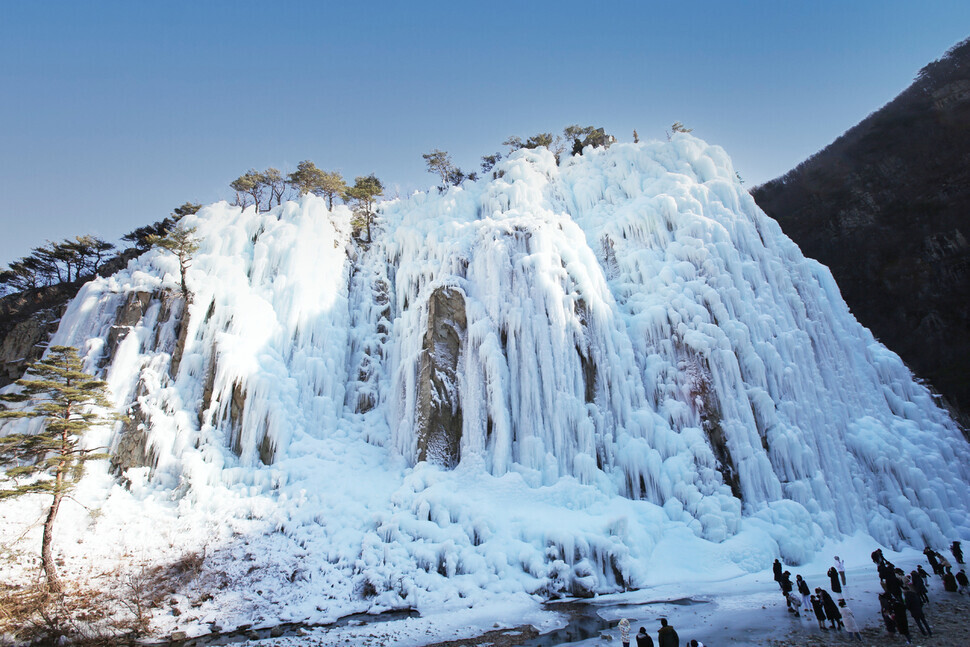
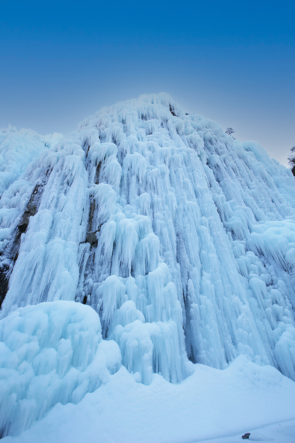
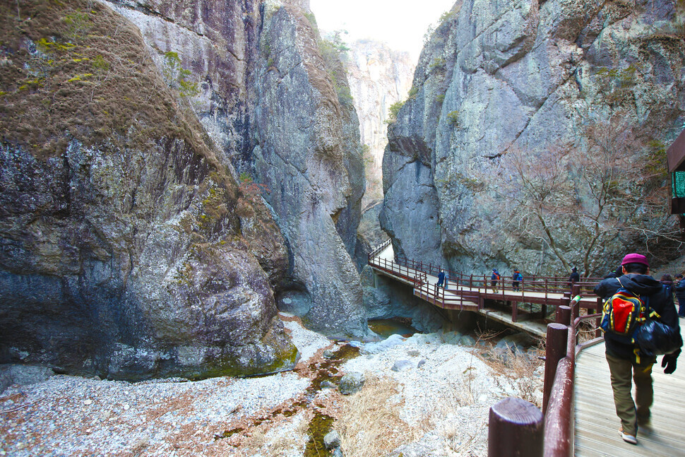
On Jan. 7, I made my way to Eoreumgol — meaning “ice valley” — in the county’s Juwangsan Township. Getting there requires following a winding mountain road with numerous dips and rises.
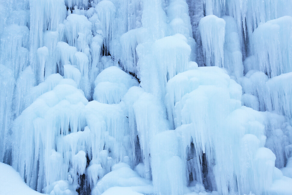
The 62-meter waterfall in the valley was frozen solid. I could hear exclamations of wonder from the travelers around me: “Wow!” “Amazing!” “What a sight!” Everyone was busy snapping shots of the ice wall, paying little heed to the chill.
Visitors here are stunned twice over, once for the sheer scale of the ice wall and again for the bizarre ice formations. Nearby, I spotted people camping out in their cars, which were parked to give them a view of the ice wall.
Despite being tucked away in a deep mountain valley, Eoreumgol has recently become a popular spot for taking stunning winter photos to share on social media. The site boasts a glacial beauty that brings to mind the film “Frozen.”
Eoreumgol is a natural refrigerator. For peculiar meteorological reasons, the seasons seem to run backwards here: there’s a warm breeze in the winter, and a cool breeze in the summer.
Ice can be observed all year round. Famously, water freezes here as the mercury rises in the dog days of summer. It’s said that ice forms on the rocks here when the temperature exceeds 32 degrees Celsius and then melts when it drops below that mark. The higher the temperature, the thicker the ice. That’s why the valley is known as a refuge from the scorching heat of summer.
Even more ice can be seen at Eoreumgol in the winter. Water is sprayed onto the cliff face to coat it with ice. The valley itself is well-positioned for freezing. The cliff slopes north, keeping it out of the blaze of the sun. Visitors in January and February are met with a magnificent wall of ice, frozen as solid as stone itself.
One spot to check out while visiting Eoreumgol is a hidden mineral spring bubbling in a small cave. The water here is renowned for its refreshing flavor and health benefits. To reach the spring, cross over the stepping stones. You can fill a water bottle at the spring, but take care not to exceed the limit of 20 liters of water per visitor.
“Many ice-climbing enthusiasts visited Cheongsong Eoreumgol because it was the site of an international ice climbing competition. Nowadays, people come from all over the country to take photos here because it has gotten noticed on social media,” said Kim Gyeong-hui, a tour guide in Cheongsong County.
Kim added that more than 5,000 visitors come on the weekends alone.
But Eoreumgol isn’t the only place to get pictures of cliffs covered with ice.
“You can also take pictures of ice walls at the Ice Climbing World Cup Stadium, which is near Eoreumgol, and at Hyeonbiam, a rock formation in Cheongsong Township,” Kim said.
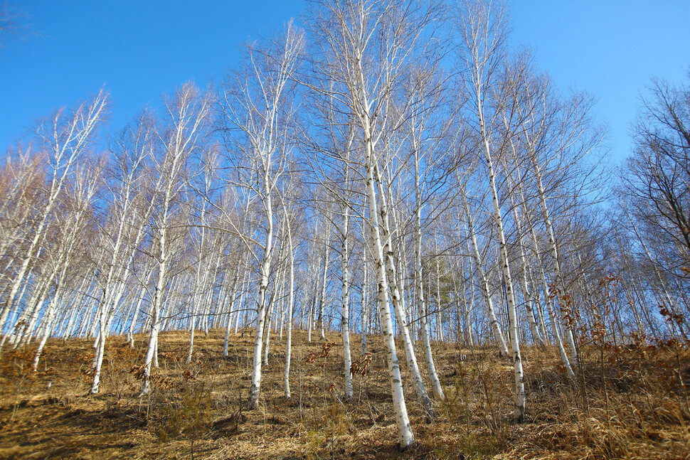
In Cheongsong, breathtaking sights lie hidden in each valley, including the silver splendor of a birch forest.
Luxury Birch Forest, as it’s called, stands at the foot of Mount Mupo (717.5 meters/2,354 feet), in Bunam Township, Cheongsong County. The forest can be reached by heading 4 kilometers up an access road from Pinamu Pass. This sprawling birch forest covers 80,000 square meters, but it’s little known and seldom visited.
There are two trekking trails here: Trail A runs for 2 kilometers and Trail B for 1 kilometer. A leisurely walk along both trails should only take an hour. The road here is unpaved and narrow, which makes it great for a nature walk. But bear in mind that there aren’t any amenities in the area — or cell phone service, for that matter.
To revel in the mountainous terrain of Cheongsong, add Juwangsan National Park located in Sangui Village, Juwangsan Township, to your travel itinerary. Together with Mount Seorak and Mount Wolchul, Mount Juwang (720.6 meters/2,364 feet) is considered one of Korea’s top three rocky mountains.
Here you can see majestic rocks of fantastical shapes and wallow in magnificent sceneries as you walk along beautiful valleys, landscapes created by rivers of lava that erupted from the earth some 70 million years ago. Though travelers flock the mountain most during the fall to admire its autumn foliage, visiting during the winter allows for a better view of the mountain’s spectacularly sculpted boulders.
There are many hiking courses in the national park that can take you to the mountain’s top. You can climb the mountain via Gamebong Peak, Jubong Peak, or Janggunbong Peak, or via Woroe Valley or Jeolgol Valley.
For an easy hike, opt for the course that takes you from Daejeon Temple near the park’s entrance to Yongchu Gorge, a 2.7-kilometer route that takes about an hour from one end to the other. The trail for this hiking course is level enough to allow for wheelchairs and strollers, and you don’t need mountain-climbing shoes to tackle this course — a pair of comfortable sneakers should be more than enough.
Following this course, you’ll get the chance to observe Giam Cliff, a rock cliff that looks like two outstretched hands supplicating the heavens; Geupsudae Columnar Joint, a rock column that formed when volcanic ash from the late Cretaceous period solidified in the shape of a hexagon; and Sirubong Peak, named thus for its resemblance to a stack of sirutteok rice cakes turned upside down. Of course, you’ll also be surrounded by numerous pine trees lining the path that go hand in hand with the Cheongsong name.
Some ways into the level hiking course, you’ll approach Yongchu Gorge, a gigantic vertical valley over 20 meters deep. The gorge is made up of otherworldly shaped rocks, in between which a path will lead you to Yongchu Waterfall.
The waterfall was formed when water flowed into the gaps between rocks, the gaps widened with time through corrosion, and a waterfall with three tiers developed in that widened space. The name “Yongchu” signifies that a dragon once lived in the waterfall, eventually ascending to the heavens.
Also known as Cheonghakdong because blue and white cranes were believed to have lived there, Yongchu Gorge was once a spot where scholars of old gathered to appreciate the beauty of nature according to tradition. One of the most popular photo spots of Mount Juwang in modern times, Yongchu Gorge and its rugged tuff cliffs have continued to earn the admiration of Koreans generation after generation.
Thanks to the many volcanic topographies observed within its borders, the entire county of Cheongsong is designated a UNESCO Global Geopark.
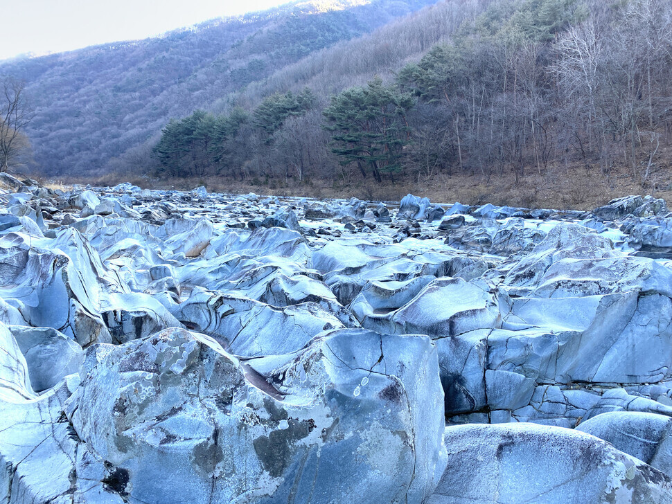
A classic example of one such volcanic landforms is the potholes of Baekseoktan Stream located in Gowa Village, Andeok Township, Cheongsong County. The name “Baekseoktan” signifies a stream where white stones gleam, and naturally, the first thing to draw your attention in Sinseong Valley will be the white rocks that dot the valley. Baekseoktan Stream is made up of sedimentary rocks that formed when sediments such as gravel, sand, and mud solidified. Their color is that of white snow because they consist of mineral particles such as quartz and feldspar that are white in color.
The white rocks of Baekseoktan Stream are significant in their pothole formations. Potholes are holes on a rock that develop when water and sand create a vortex upon a rock’s base, boring into it over a long period of time. The potholes in Baekseoktan Stream filled with water resemble lakes on snow-covered mountain tops. The white rocks of the stream are varied in shape, some pointy and some long and wide. Looking at the beautiful white rocks of Baekseoktan Stream, you’ll feel as if you’re witnessing rock sculptures hand-carved by nature herself.
A short jaunt by car from Baekseoktan Stream will lead you to another mysterious landscape shaped by nature herself — a lookout in Sinseong Valley that overlooks a “mini-Korean Peninsula.”
After a 10-minute hike up steep inclines, you’ll arrive at a lookout with an incredible view of a river winding around a mountain on three sides, just as the sea surrounds the Korean Peninsula.
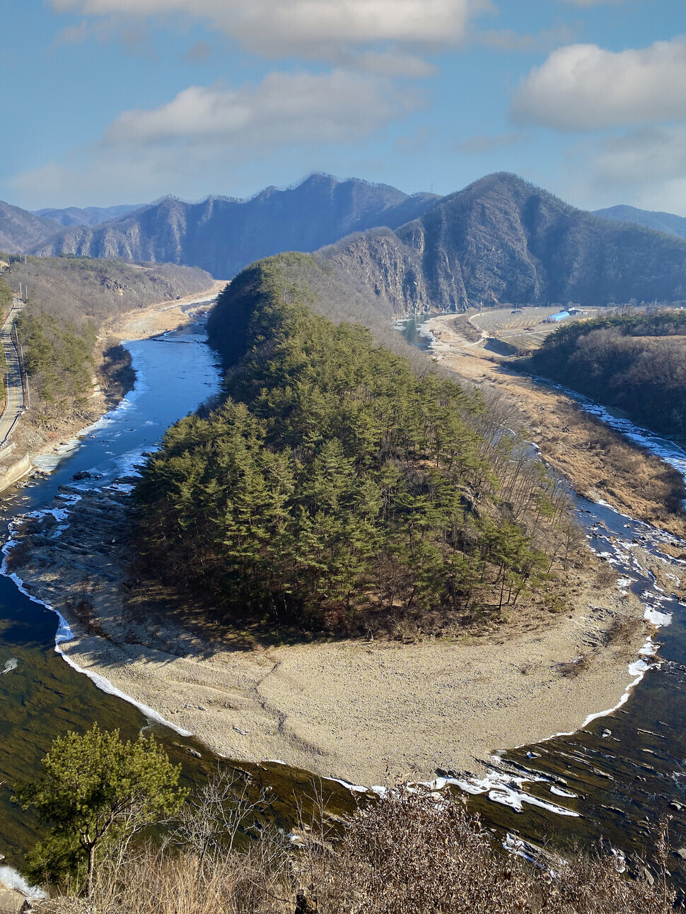
The terrain is a result of active erosion caused by the river’s base level rising. Such sections of rivers are called incised meanders and are also known as “sahaengcheon” or “moving snake streams” in Korean for their resemblance to the twisting and turning movement of snakes. Because erosion continues on the outer bank where the water’s current is faster while sediments accumulate on the inner bank where the water’s current is slower, the curves of incised meanders exaggerate as time passes.
For a relaxing time to take in the scenery, take the Sinseong Valley Green Road Geotrail. The Sinseong Valley Green Road Geotrail is 12.4 kilometers long and has three courses, of which Course 3, also known as Baekseoktan Stream road, is best for walking.
The 4.7 km-long Course 3 begins at the Firefly Farm located in Jiso Village, Andeok Township, and ends at Mokeunjae Rest Area in Gowa Village. A road less taken than Courses 1 and 2, the trail allows for a breathtaking view of Baekseoktan Valley and an adventure into mysterious geological features, a unique look into nature especially when undertaken at a leisurely pace.
By Her Yun-hee, staff reporter
*This article was reported and written in strict accordance with COVID-19 guidelines.
■ Cheongsong Travel Information
■ Transportation: A bus bound to Cheongsong Intercity Bus Terminal leaves Dong Seoul Terminal (Inquiries: ti21.co.kr, 1688-5979) four times a day between 8:40 am and 15:30 pm. The bus ride takes 4 hours and 10 minutes and costs 31,500 won. A nonstop bus to Juwangsan Intercity Bus Terminal leaves Dong Seoul Terminal four times a day as well. This option is ideal for hikers of Mount Juwang. From the same terminal, a bus to Jinbo Terminal located in Jinan Village, Jinbo Township, Cheongsong County, North Gyeongsang Province, leaves six times a day between 8:10 am and 16:20 pm. From there, travelers can use local buses that operate within Cheongsong County to reach Mount Juwang, Jusanji Reservoir, and other destinations.
■ Lodging: Minyechon (842 Haui Village, Juwangsan Township, Cheongsong County; 054-874-9098), operated by Cheongsong Culture & Tourism Foundation, provides lodging in traditional hanok homes to travelers. Accommodation is also available at Songso Historic House (176 Deokcheon Village, Pacheon Township, Cheongsong County; 054-874-6556), designated as National Folklore Cultural Heritage No. 250 by the Korean government. Sono Belle Cheongsong (494-1 Juwangsan Road, Juwangsan Township, Cheongsong County; 1588-4888) can be an option for travelers looking to lodge in resort hotels. The rate for one weekday night is around 100,000 won. The resort is famous for its Solsaem Hot Spring.
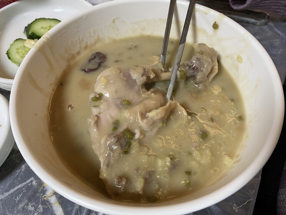
■ Food: Cheongsong is famous for its baeksuk, whole chicken boiled in mineral spring water. Travelers may check out chicken baeksuk restaurants clustered around Dalgi Yaksutang located in Bugok Village, Cheongseong Township, Cheongsong County, or Sinchon Yaksutang located in Sinchon Village, Jinbo Township.
Please direct questions or comments to [english@hani.co.kr]

Editorial・opinion
![[Editorial] Intensifying US-China rivalry means Seoul must address uncertainty with Beijing sooner than later](https://flexible.img.hani.co.kr/flexible/normal/500/300/imgdb/original/2024/0517/8117159322045222.jpg "[Editorial] Intensifying US-China rivalry means Seoul must address uncertainty with Beijing sooner than later") [Editorial] Intensifying US-China rivalry means Seoul must address uncertainty with Beijing sooner than later
[Editorial] Intensifying US-China rivalry means Seoul must address uncertainty with Beijing sooner than later![[Column] When ‘fairness’ means hate and violence](https://flexible.img.hani.co.kr/flexible/normal/500/300/imgdb/original/2024/0516/7417158465908824.jpg "[Column] When ‘fairness’ means hate and violence") [Column] When ‘fairness’ means hate and violence
[Column] When ‘fairness’ means hate and violence- [Editorial] Yoon must stop abusing authority to shield himself from investigation
- [Column] US troop withdrawal from Korea could be the Acheson Line all over
- [Column] How to win back readers who’ve turned to YouTube for news
- [Column] Welcome to the president’s pity party
- [Editorial] Korea must respond firmly to Japan’s attempt to usurp Line
- [Editorial] Transfers of prosecutors investigating Korea’s first lady send chilling message
- [Column] Will Seoul’s ties with Moscow really recover on their own?
- [Column] Samsung’s ‘lost decade’ and Lee Jae-yong’s mismatched chopsticks
Most viewed articles
- 1[Editorial] Transfers of prosecutors investigating Korea’s first lady send chilling message
- 2[Exclusive] Unearthed memo suggests Gwangju Uprising missing may have been cremated
- 3[Column] US troop withdrawal from Korea could be the Acheson Line all over
- 4[Column] When ‘fairness’ means hate and violence
- 5[Editorial] Intensifying US-China rivalry means Seoul must address uncertainty with Beijing sooner t
- 6‘Shot, stabbed, piled on a truck’: Mystery of missing dead at Gwangju Prison
- 7S. Korea “monitoring developments” after report of secret Chinese police station in Seoul
- 8China calls US tariffs ‘madness,’ warns of full-on trade conflict
- 9Seoul government announces comprehensive measures to prevent lonely deaths
- 10[Column] How to win back readers who’ve turned to YouTube for news