hankyoreh
Links to other country sites 다른 나라 사이트 링크
[Feature] Tracing global warming’s toll to Tuvalu
Global warming is invisible. Just as a frog in a slowly warming frying pan cannot sense his impending doom, so, too, are humans unaware of the global disaster that is descending upon them. Yet the island nation of Tuvalu offers an all too palpable example of global warming’s consequences. As the northern ice caps thaw and the oceans swell with additional water, the sea level slowly rises. Low-lying Pacific coral atolls such as Tuvalu are particularly vulnerable to the waves. Is it inevitable that they will one day share the same fate as the legendary island of Atlantis, disappearing below the waves for eternity. In order to better grasp the nature of global warming and the threat that it harbors, Hankyoreh 21 launched an expedition to the equatorial island nation of Tuvalu.
***
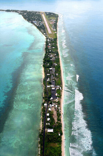
TUVALU=As our airplane entered Tuvalu’s airspace, the Funafuti Atoll fire trucks circled the runway, sirens blaring. The old men napping beside the airstrip awoke yawning, and the children playing soccer on the landing field regrouped at the airport to watch the airplane touch down. The siren that rings every Thursday at 12:30 PM brings some 200 to 300 of the Funafuti Atoll’s 9,500 residents to the airport to see the [weekly] airplane landing. They watch with interest as the inbound plane lands and brakes firmly so as not to run off the short airstrip.
With cool winds tempering the heat of this equatorial Pacific atoll around 4:30 PM, people once more gathered on and around the airstrip. This time, they were preparing for the atoll-wide soccer tournament. Youths retook their positions on the field, eager to practice. Others took to their bicycles, pedaling about. Before long, the setting sun extinguished and families laid out mats across the concrete to sleep for the night beneath the open sky.
In the event of a flood, the residents mostly gather around the landing field, as well. On this 12-kilometer long snakelike atoll, the airstrip sits atop the widest part of the narrow land. Though this section is only 400 meters wide and 3.7 meters above sea level, the runway offers the safest spot available.
The airstrip was constructed in 1943. The first prime minister after Tuvalu gained independence from Great Britain in 1978, Toaripi Lauti, 76, explained, "the American military came during World War II and dispersed the Funafuti residents to other islands so that they could build a runway." In order to elevate the land, it was necessary to pile up sand. Thus, American armored vehicles brought in sand from the Northern and Southern coasts." Lauti continued, "The Americans dug up the land here and there to gather sand. That's why there are craters. The Tuvalu residents call these ’borrow pits.’ "
The American soldiers tore out the pulaka (taro) plants and coconut trees, which made up the staple diet of the inhabitants. In their place, the U.S. military ’planted’ airfields and military facilities. They paid the inhabitants in U.S. dollars, which were of little use to them.
As the years passed, water started to well up in the pits that the Americans had dug. Forty to 50 years later, the water levels started to rise at a greater rate, and the Tuvaluans found themselves under a new threat.
We reached Funafuti on 26 February, just one week until the tide would reach its high point on the 15th day of the lunar month. We thus settled in for a week of reporting and taking in the scenery of the Pacific atolls.
During this time, we met with Tomu M. Sione, 64, the Minister of the Natural resource. He said that "there is a flood twice every month. The floods started 10 years ago." On the 15th and final day of the lunar month, the tide reaches its zenith. He continued, "the high tides progressively grow higher, and the low tides grow lower. Even the variation of diurnal tides is increasing."
We journeyed to a village on the outskirts of the atoll to examine the borrow pits there. Wooden houses, pigsties, and chicken coops surround the pits. Scattered garbage skirts the landscape. At low tide, the bottom of the borrow pits is visible, but at high tide, the holes begin to overflow.
Lee Khalo Morsei, 36, said, "Funafuti’s coral reefs are hollow," continuing, "when the sea rises, the underground water becomes mixed with the ocean water." On the 11th day of the lunar calendar, the water level was still not high enough to even threaten the nearby pigsty. But the choice of housing revealed that something was plaguing the residents: people nearby all dwell in huts on stilts, elevated some 1 to 1.5 meters above the ground.
Temukisa Maumau, 55, indicated on one of such stilts the height of the highest water level recorded over the past ten years. When we ascended her two-story house, she offered us each a chair. Then, in uneasy English, she told them, "The first floor is no longer safe."
"February of last year was the worst. The water reached as high as the roof of the first floor. The dining room table and television were all ruined. Ten years ago, this would never have happened."
A picture from the flood that she mentioned hangs in the Meteorological Service. Its employees took a picture in front of the drenched weather equipment on the front lawn of their headquarters. They even put the picture on the government Web site, with a caption appealing to those who do not believe that the sea level is rising: "Senior Scientific Officer Tavala Katea said ’Tuvalu’s weather observation equipment was top class.’ The water rose to 3.48 meters above sea level. The highest point on this atoll is but 3.7 meters above sea level," the caption read.
In other words, all that separated the atoll from total immersion was a mere 22 centimeters. The annual rate of the sea’s rise between 1993 to January of 2007 stood at 5.5 millimeters. During the spring high tide of January to March, the seawater rises anywhere from 2.9 to 3.4 meters. In ten years, this will become 2.96 to 3.73 meters. In other words, the entire atoll will be engulfed during this spring high tide in the near future.
"The rise of the sea level is changing Tuvalu’s ecosystem," said Senior Scientific Officer Katea. Because of the eruptions of salty subterranean water, drinking water has become all but unattainable, and the coconut trees are dying out. Yet the rise of the sea level is not the only thing affecting the local ecology. Strong winds that once came to the atoll but once or twice a year now occur every month and with greater force. It is a fatal combination when the driving winds combine with the spring tide. As there are no hills upon which to seek refuge, and the people are bereft of a raft like Noah’s, they can only pray that the two natural phenomena do not coincide. The fear that they hold does not only stem from the monthly floods, for they saw glimpses of a terrible future through Hurricane Katrina and the Tsunami that tore across South and Southeast Asia.
Seaman Vayakua Pattinga, regarding the rise of the sea level, said, "The media’s always blathering on about it...beats me." With this, he unfurled a languid smile. After a moment of silence, he confided to us, "I want to leave this country. When the spring tide comes and the gale winds blow, it will be over for us. We realize that disaster is all too certain to strike us."
When his father, living on the atoll of Nukufetau, 100 kilometers from Funaputi atoll, passes away, he intends to take his wife and two sons and immigrate to New Zealand. The stakes supporting his house are already two-thirds submerged.
Every single local that we met expressed a desire to leave - from Maumau the wife of the architect to Patina the seaman, and even the nation’s first prime minister, his excellency Lauti. "I have sent migration requests to Australia since 2005" said Maumau, "but in their reply, they said they accept no one over the age of 45. My son living in Australia must bear four children in order for me to gain permission to go." In a laugh tinged with self-derision, Maumau declared, "I am trapped in Tuvalu."
Lauti is one of several people calling for a mass exodus from the atoll nation. In particular, he proclaims the need for a ’national relocation.’ "The government must negotiate with other countries in establishing a new land for settlement. The government fears the dissolution of their state upon relocation, but we can move while maintaining our nation. In particular, we ought to consider islands that are close to the marketplaces of the world, such as would be the case as far as islands near Taiwan and Okinawa."
The reason Lauti has voiced this proposal is that he has given up all hope of developed nations cutting down on greenhouse gas emissions. In 1997, he took part as an envoy to the Kyoto Protocol discussions, where he spoke of the crisis facing his homeland. "Both then and now," he said, "the lazy stance taken by the U.S. and Australia are disappointing."
The U.N.-sponsored Intergovernmental Panel on Climate Change last February announced that the carbon dioxide levels have risen from 280 parts per million (ppm) before the industrial revolution to a present high of 379 ppm. They also announced that Northern Arctic ice and the glaciers of Greenland are melting. The average rate by which the global sea level rose from 1961 to 2003 was 1.8 mm a year, and this rate was 5.5 mm a year in Tuvalu, the panel said.
Tuvalu Minister of the Natural Resource Tomu M. Sione asserted, "the powerful, industrialized, and developing nations are responsible for the crisis that Tuvalu faces." The carbon dioxide emissions from these countries has made the Earth into a greenhouse.
According to the 2004 report by the International Energy Agency, the U.S. emits the most carbon dioxide per capita, at 19.73 tons a person, Australia emits 17.53 tons per capita, Korea emits 9.61 tons per capita, and New Zealand emits 8.04 tons per capita. According to a 1996 U.N. report, Tuvalu emits but 0.46 tons per capita.
The residents of Tepuka Savilivili, an island 10 kilometers away from Funafuti, also sense the crisis. One day in 1997, an uninhabited island simply vanished. The residents explained that gale winds blew and covered the island during the night. The next day, the coconut trees had vanished.
Currently, Tepuka Savilivili is but a 100-pyeong clump of coral. Above the white coral lies plastic bottles, asbestos fragments, and Johnson’s Baby Lotion bottles, all spewed out by the waves. Yet over the years, coconut trees on the island have also sprouted new buds.
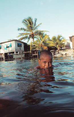
Time flowed on toward full moon day, the 15th day of the lunar month. The island began to silently change. Water started gathering in the fields surrounding the airstrip. Water soaked the taro fields. Bubbles rose from the earth - evidence of the water’s rise. As the water is highly saline, the taros stood no chance. Though the farmers worked to raise the land and block the intrusion, the fields were already littered with jaundiced taro.
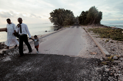
Finally came the 15th day of the lunar month - March 4. The Weather Bureau forecast that the tide would rise to 2.94 meters above sea level. High tide was predicted at 5:26 pm. The borrow pits around Funafuti’s perimeter had become lakes. The pigsties, chicken coops, and garbage bins were all immersed. The seawater that arose from the borrow pits rose against the residents’ houses. Within the village, the children played volleyball in the ankle-deep water. The stepping stones [laid in a park] only days before disappeared beneath the water. A newly formed river cut off the road leading to the beachfront houses. A little boy paused in awe at the water’s approach before scampering back to the temporary safety of his house.
Article by Nam Jong-yeong
Please direct questions or comments to [englishhani@hani.co.kr]
Editorial・opinion
![[Column] Park Geun-hye déjà vu in Yoon Suk-yeol](https://flexible.img.hani.co.kr/flexible/normal/500/300/imgdb/original/2024/0424/651713945113788.jpg "[Column] Park Geun-hye déjà vu in Yoon Suk-yeol") [Column] Park Geun-hye déjà vu in Yoon Suk-yeol
[Column] Park Geun-hye déjà vu in Yoon Suk-yeol![[Editorial] New weight of N. Korea’s nuclear threats makes dialogue all the more urgent](https://flexible.img.hani.co.kr/flexible/normal/500/300/imgdb/original/2024/0424/7317139454662664.jpg "[Editorial] New weight of N. Korea’s nuclear threats makes dialogue all the more urgent") [Editorial] New weight of N. Korea’s nuclear threats makes dialogue all the more urgent
[Editorial] New weight of N. Korea’s nuclear threats makes dialogue all the more urgent- [Guest essay] The real reason Korea’s new right wants to dub Rhee a founding father
- [Column] ‘Choson’: Is it time we start referring to N. Korea in its own terms?
- [Editorial] Japan’s rewriting of history with Korea has gone too far
- [Column] The president’s questionable capacity for dialogue
- [Column] Are chaebol firms just pizza pies for families to divvy up as they please?
- [Column] Has Korea, too, crossed the Rubicon on China?
- [Correspondent’s column] In Japan’s alliance with US, echoes of its past alliances with UK
- [Editorial] Does Yoon think the Korean public is wrong?
Most viewed articles
- 1‘We must say no’: Seoul defense chief on Korean, USFK involvement in hypothetical Taiwan crisis
- 2N. Korean delegation’s trip to Iran shows how Pyongyang is leveraging ties with Moscow
- 3Amnesty notes ‘erosion’ of freedom of expression in Korea in annual human rights report
- 4[Column] Park Geun-hye déjà vu in Yoon Suk-yeol
- 5‘Weddingflation’ breaks the bank for Korean couples-to-be
- 6[Reportage] On US campuses, student risk arrest as they call for divestment from Israel
- 7[Editorial] New weight of N. Korea’s nuclear threats makes dialogue all the more urgent
- 8Why Korea shouldn’t welcome Japan’s newly beefed up defense cooperation with US
- 9[Guest essay] The real reason Korea’s new right wants to dub Rhee a founding father
- 10Will NewJeans end up collateral damage in internal feud at K-pop juggernaut Hybe?