hankyoreh
Links to other country sites 다른 나라 사이트 링크
Pre-colonial Japanese textbooks mark Dokdo as Korean territory
By Song In-geol, Daejeon correspondent
Japanese textbooks have been found by that describe Dokdo as Korean territory. On August 28, the Independence Hall of Korea announced its discovery of five Japanese textbooks and two atlases published between 1886 and 1925.
The national institution made public five textbooks and two atlases, all but one of which were published before Japan’s occupation of Korea, which started in 1910. Among the texts were four geography textbooks and one history textbook, along with two atlases.
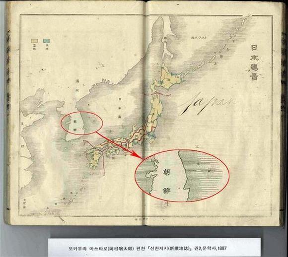
Okamuru’s 1887 textbook’s map of Japan surrounds Japan’s nearby islands with a shaded area, thus marking them as Japanese territory. Ulleungdo and Dokdo are included in the shaded area marked as Korean territory.
The map of Japan in the 1905 textbook marks the Ryukyu Islands (Okinawa); Taiwan, which Japan colonized in 1894; and the northern Chishima (Kuril) Islands as Japanese territory, but Dokdo is clearly marked as belonging to Korea.
The 1886 history book marks Tsushima, Okinawa and other islands as Japanese, but Dokdo is not separately marked.
Independence Hall of Korea researcher Yoon So-young said, “The documents prove that Japan’s claim that Dokdo is historically Japanese territory is baseless and that the islands are in fact Korean territory. We determine that Japan had no territorial awareness of Dokdo prior to its forced occupation of the islets during the 1905 Russo-Japanese War, when they were forcibly incorporated into Shimane Prefecture. Even the textbooks published by the Japanese government reflect this lack of awareness.”
Some scholars have expressed the opinion that there are limits to how far these materials can be seen as conclusive evidence to support Dokdo being Korean territory.
Seowon University professor Sim Jeong-bo, an expert on old Japanese maps, said, “Conclusive evidence would be a government map, attached to an official document related to a government decision, which says Japan has no sovereignty over Dokdo or marks Dokdo as Korean territory. These materials contain no such maps.”
Northeast Asian History Foundation researcher Kwak Jin-o said, “Japan claims Dokdo was annexed by Japan with an official announcement by Shimane Prefecture on Feb 22, 1905; Japanese textbooks from before this hardly mark Dokdo. It appears the materials released this time are similar.”
The textbooks were an elementary school geography textbook published by the Japanese Ministry of Education(小學地理用新地圖) in 1905, a Japanese history textbook(日本史要 卷上) screened by the Japanese Ministry of Education in 1886, another elementary school geography textbook(小學地理 1·2券) screened by the Japanese Ministry of Education in 1900, a geography textbook (新撰地誌 1) published by Okamuru Matsudaro in 1887, and a Japanese geography textbook (分邦詳密日本地圖) written by Otsuki Shuji in 1878.
The two atlases were one (日本地誌要略 1·4券) written by Aoki Tsunesaburo in 1878 and one (標準日本地圖) published by a Tokyo publishing house in 1925.
Please direct questions or comments to [english@hani.co.kr]

Editorial・opinion
![[Guest essay] Amending the Constitution is Yoon’s key to leaving office in public’s good graces](https://flexible.img.hani.co.kr/flexible/normal/500/300/imgdb/original/2024/0416/8917132552387962.jpg "[Guest essay] Amending the Constitution is Yoon’s key to leaving office in public’s good graces") [Guest essay] Amending the Constitution is Yoon’s key to leaving office in public’s good graces
[Guest essay] Amending the Constitution is Yoon’s key to leaving office in public’s good graces![[Editorial] 10 years on, lessons of Sewol tragedy must never be forgotten](https://flexible.img.hani.co.kr/flexible/normal/500/300/imgdb/original/2024/0416/8317132536568958.jpg "[Editorial] 10 years on, lessons of Sewol tragedy must never be forgotten") [Editorial] 10 years on, lessons of Sewol tragedy must never be forgotten
[Editorial] 10 years on, lessons of Sewol tragedy must never be forgotten- [Column] A death blow to Korea’s prosecutor politics
- [Correspondent’s column] The US and the end of Japanese pacifism
- [Guest essay] How Korea turned its trainee doctors into monsters
- [Guest essay] As someone who helped forge Seoul-Moscow ties, their status today troubles me
- [Editorial] Koreans sent a loud and clear message to Yoon
- [Column] In Korea’s midterm elections, it’s time for accountability
- [Guest essay] At only 26, I’ve seen 4 wars in my home of Gaza
- [Column] Syngman Rhee’s bloody legacy in Jeju
Most viewed articles
- 1[Guest essay] How Korea turned its trainee doctors into monsters
- 2Faith in the power of memory: Why these teens carry yellow ribbons for Sewol
- 3[Editorial] 10 years on, lessons of Sewol tragedy must never be forgotten
- 4[Guest essay] Amending the Constitution is Yoon’s key to leaving office in public’s good graces
- 5Korea ranks among 10 countries going backward on coal power, report shows
- 6Final search of Sewol hull complete, with 5 victims still missing
- 7[News analysis] Watershed augmentation of US-Japan alliance to put Korea’s diplomacy to the test
- 8How Samsung’s promises of cutting-edge tech won US semiconductor grants on par with TSMC
- 9K-pop a major contributor to boom in physical album sales worldwide, says IFPI analyst
- 10World famous Korean instant noodle: truth and misconceptions