hankyoreh
Links to other country sites 다른 나라 사이트 링크
North Korean drone conducted reconnaissance over THAAD deployment site
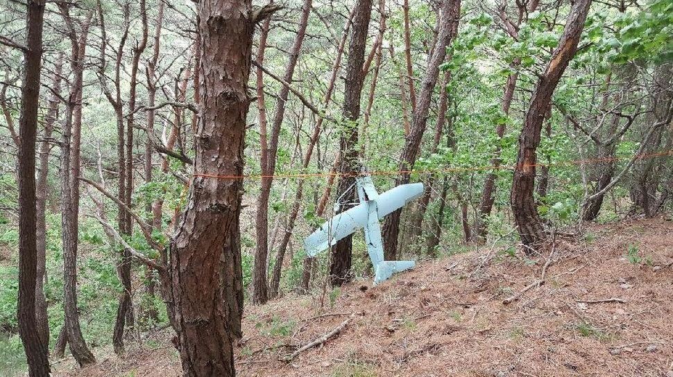
A suspected North Korean drone discovered in Gangwon Province’s Inje County on June 9 was found to have conducted reconnaissance in North Gyeongsang Province’s Seongju region, where the THAAD system is deployed.
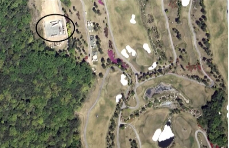
In particular, the small aircraft was found to have taken roughly a dozen photographs over the Seongju golf course where THAAD is deployed. The incident is the first time a suspected North Korean drone has traveled that far south.
According to accounts from the Ministry of National Defense on June 13, analysis of the drone‘s camera showed it had begun photographing while traveling south several kilometers north of the golf course, with an especially large number of pictures taken of the THAAD deployment site where it was traveling back north. Photographs found on the drone showed two launchers and fire control radar deployed on Apr. 26, indicating they were taken after the THAAD deployment.
“The drone took hundreds of pictures, of which around ten were photographs of the Seongju region where THAAD is deployed,” a military source said.
“Most of the hundreds of photographs showed forests, fields, and residential areas, and pictures were also taken of the Inje area [in Gangwon Province] as it was heading back north after photographing the THAAD deployment area,” the source said.
The drone was found to have taken photographs at an altitude of two to three kilometers, with low enough resolution that the THAAD launchers and radar were only faintly visible when enlarged. Military authorities were reported to have tentatively concluded the drone ran out of fuel and crashed while traveling north toward the Military Demarcation Line (MDL) after photographing the Seongju area.
North Korean drones discovered in Paju, Gyeonggi Province and on Baengnyeong Island and in Samcheok, Gangwon Province, in Mar. and Apr. 2014 were found to have conducted reconnaissance in areas relatively close to the MDL, including the Seoul area and the northwest islands. The distance from the MDL to Seongju is around 270 km. The distance suggests improvements in North Korean drone technology, including substantially longer travel distances.
After receiving a report from the Joint Chiefs of Staff headquarters on the afternoon of June 13, National Assembly National Defense Committee chairperson Kim Young-woo said authorities were “helpless when a drone that is too small for radar to detect enters our airspace.”
“Instead of focusing too much on increasing size with large and advanced weapons, we need a system to respond to practical threats,” Kim said.
Military authorities plan to investigate further and make an official announcement as early as the beginning of next week on its analysis of the drone’s base and intended return point.
By Lee Kyung-mi and Jung In-hwan, staff reporters
Please direct questions or comments to [english@hani.co.kr]

Editorial・opinion
![[Editorial] Penalties for airing allegations against Korea’s first lady endanger free press](https://flexible.img.hani.co.kr/flexible/normal/500/300/imgdb/original/2024/0502/1817146398095106.jpg "[Editorial] Penalties for airing allegations against Korea’s first lady endanger free press") [Editorial] Penalties for airing allegations against Korea’s first lady endanger free press
[Editorial] Penalties for airing allegations against Korea’s first lady endanger free press![[Editorial] Yoon must halt procurement of SM-3 interceptor missiles](https://flexible.img.hani.co.kr/flexible/normal/500/300/imgdb/child/2024/0501/17145495551605_1717145495195344.jpg "[Editorial] Yoon must halt procurement of SM-3 interceptor missiles") [Editorial] Yoon must halt procurement of SM-3 interceptor missiles
[Editorial] Yoon must halt procurement of SM-3 interceptor missiles- [Guest essay] Maybe Korea’s rapid population decline is an opportunity, not a crisis
- [Column] Can Yoon steer diplomacy with Russia, China back on track?
- [Column] Season 2 of special prosecutor probe may be coming to Korea soon
- [Column] Park Geun-hye déjà vu in Yoon Suk-yeol
- [Editorial] New weight of N. Korea’s nuclear threats makes dialogue all the more urgent
- [Guest essay] The real reason Korea’s new right wants to dub Rhee a founding father
- [Column] ‘Choson’: Is it time we start referring to N. Korea in its own terms?
- [Editorial] Japan’s rewriting of history with Korea has gone too far
Most viewed articles
- 1[Editorial] Penalties for airing allegations against Korea’s first lady endanger free press
- 260% of young Koreans see no need to have kids after marriage
- 3Months and months of overdue wages are pushing migrant workers in Korea into debt
- 4Bills for Itaewon crush inquiry, special counsel probe into Marine’s death pass National Assembly
- 51 in 3 S. Korean security experts support nuclear armament, CSIS finds
- 6[Guest essay] Maybe Korea’s rapid population decline is an opportunity, not a crisis
- 7[Reporter’s notebook] In Min’s world, she’s the artist — and NewJeans is her art
- 8[Editorial] Yoon must halt procurement of SM-3 interceptor missiles
- 9S. Korea discusses participation in defense development with AUKUS alliance
- 10Cracks found in containment building of UAE nuclear power plant built by S. Korean companies