hankyoreh
Links to other country sites 다른 나라 사이트 링크
Climate change radically alters S. Korea’s monsoon rains
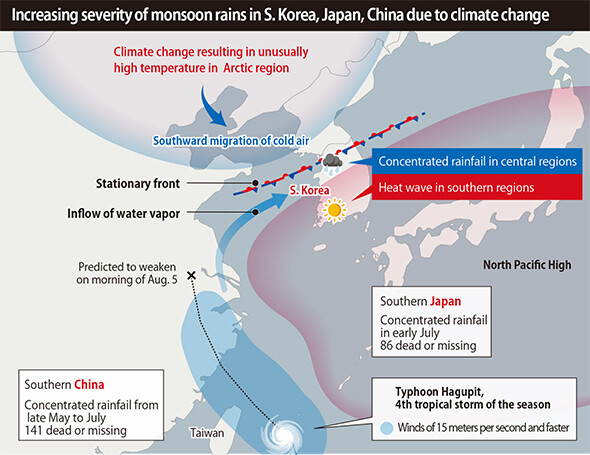
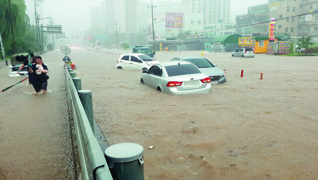
After being soaked with rainfall of over 300mm over the past two days, central South Korea is facing the prospect of additional losses with more heavy rains of over 500mm predicted to fall through Aug. 5. The Korea Meteorological Administration (KMA) has forecasted heavy rains concentrated in Seoul and Gyeonggi Province and in western Gangwon Province amid the effects of Typhoon Hagupit, the fourth tropical storm of the season. Having already caused 141 deaths in China and 86 in Japan, a “super-monsoon” spawned by climate change is now laying into South Korea.
“Amid a heavy rain alert in effect for the central region, many areas with be experiencing very heavy rain of 50-100mm per hour (over 120mm in some regions) combined with strong winds, thunder, and lightning through Aug. 4, particularly in Seoul/Gyeonggi Province and western Gangwon Province,” the KMA announced on Aug. 3.
Between 6 pm on Aug. 1 and 4 pm on Aug. 3, rainfall of around 300mm fell in parts of Gyeonggi Province, western Gangwon Province, and North Chungcheong Province, including 376mm in Iljuk Township in Anseong, Gyeonggi Province, 287.5mm at Yangji Township in Cheorwon, Gangwon Province, and 310.0mm in Yeongchun Township in Danyang, North Chungcheong Province. The KMA is predicting additional rainfall in excess of 500mm for central South Korea through Aug. 5.
The heavy rains during this year’s monsoon season in East Asia were attributed to the same cause. Lee Hyeon-su, director of the KMA’s climate forecasting bureau, concluded that a “phenomenon of unusually high temperatures in the Arctic region due to climate change has been a factor behind the unusual climate patterns in East Asia this summer.” As temperatures more than twice as high as those in ordinary years have occurred in the polar region, upper jet stream currents have weakened, establishing the conditions for cold air from the North Pole to descend to the middle latitudes. Meanwhile, two blocking patterns (tall centers of high pressure) formed in the Ural Mountains and in northeastern China have also led to a continued supply of cold air to the central latitudes.
In normal years, a strong North Pacific High would be developing and expanding northward. Trapped by the cold air, stationary fronts stretching for thousands of kilometers have been moving back and forth without traveling to the north, resulting in heavy rains concentrated over parts of East Asia. In China, torrential rains that began on May 29 in the south have continued for over two months in the central and northern regions of the country, drenching the center and south -- the provinces of Jiangxi, Anhui, Guizhou, and Hubei -- and causing the death or disappearance of 141 people. In Japan, 82 people have died and four are missing after one or two weeks of sustained heavy rains, with Kyushu experiencing its regular monthly rainfall during a single day in early July.
But while air pressure system changes in East Asia due to climate change provide a prerequisite for the “super-monsoon” phenomenon, they are not sufficient to explain the concentration of heavy rains in particular regions at particular times.
“In some respects, the record rainfall this year can’t be viewed solely in terms of stationary fronts,” said Kim Hae-dong, a professor of earth and environmental sciences at Keimyung University.
“As a supply of vapor like an atmospheric river [a long and narrow corridor of intense moisture at the upper layers of the atmosphere] settles on top of a stationary front, it leads to unexpected torrential rains of the kind that occurred on Mt. Jiri in 1998,” he explained.
Precipitation principles in S. Korea, Japan, China have all variedChang Eun-cheol, a professor of atmospheric science at Kongju National University, said, “Strictly speaking, even with the same stationary front, the precipitation principles at work in South Korea, China, and Japan have all been different.”
“In China’s case, it’s been cumulus precipitation developing from a thermally warm ground, while in South Korea the precipitation is the result of a low pressure boundary combining with the front,” he explained.
The intensity of the North Pacific High -- which has been showing a trend of increase recently due to climate change -- has not weakened this year. Held back by cold air to the north, the North Pacific High has stretched as far as southern China. As a result, South Korea was expected to move outside the scope of Typhoon Hagupit as it made landfall in China early in the morning of Aug. 4, traveling along the edges of the high pressure system. But with the North Pacific High skewing southward, vapor left behind by the typhoon is expected to arrive in South Korea on Aug. 5, using the stationary front as its “highway.”
By Lee Keun-young, staff reporter
Please direct comments or questions to [english@hani.co.kr]

Editorial・opinion
![[Column] Season 2 of special prosecutor probe may be coming to Korea soon](https://flexible.img.hani.co.kr/flexible/normal/500/300/imgdb/original/2024/0426/3317141030699447.jpg "[Column] Season 2 of special prosecutor probe may be coming to Korea soon") [Column] Season 2 of special prosecutor probe may be coming to Korea soon
[Column] Season 2 of special prosecutor probe may be coming to Korea soon![[Column] Park Geun-hye déjà vu in Yoon Suk-yeol](https://flexible.img.hani.co.kr/flexible/normal/500/300/imgdb/original/2024/0424/651713945113788.jpg "[Column] Park Geun-hye déjà vu in Yoon Suk-yeol") [Column] Park Geun-hye déjà vu in Yoon Suk-yeol
[Column] Park Geun-hye déjà vu in Yoon Suk-yeol- [Editorial] New weight of N. Korea’s nuclear threats makes dialogue all the more urgent
- [Guest essay] The real reason Korea’s new right wants to dub Rhee a founding father
- [Column] ‘Choson’: Is it time we start referring to N. Korea in its own terms?
- [Editorial] Japan’s rewriting of history with Korea has gone too far
- [Column] The president’s questionable capacity for dialogue
- [Column] Are chaebol firms just pizza pies for families to divvy up as they please?
- [Column] Has Korea, too, crossed the Rubicon on China?
- [Correspondent’s column] In Japan’s alliance with US, echoes of its past alliances with UK
Most viewed articles
- 1Samsung subcontractor worker commits suicide from work stress
- 2‘We must say no’: Seoul defense chief on Korean, USFK involvement in hypothetical Taiwan crisis
- 3[Editorial] Korea’s surprise Q1 growth requires objective assessment, not blind fanfare
- 4Division commander ordered troops to enter raging flood waters before Marine died, survivor says
- 5Is Japan about to snatch control of Line messenger from Korea’s Naver?
- 6No good, very bad game for Korea puts it out of Olympics for first time since 1988
- 7US overtakes China as Korea’s top export market, prompting trade sanction jitters
- 8N. Korean delegation’s trip to Iran shows how Pyongyang is leveraging ties with Moscow
- 9Korea’s 1.3% growth in Q1 signals ‘textbook’ return to growth, says government
- 10[Column] Season 2 of special prosecutor probe may be coming to Korea soon