hankyoreh
Links to other country sites 다른 나라 사이트 링크
Semi-basements, underpasses: Why does flooding keep turning deadly in Korea?
An underpass. A semi-basement residence. An underground parking garage. Another underpass.
When heavy rains and typhoons hit Korea each summer, the damage in urban areas has tended to be concentrated on low-lying underground locations. But in spite of the punishments and measures that are implemented, similar tragedies keep playing out every year.
Whenever a disaster strikes, the institutions in charge develop a protocol and carry out inspections. But according to analysts, the disasters keep repeating themselves as a result of the obligations being spread across different organizations — and of even those measures not being implemented in a timely fashion due to budget constraints and other factors.
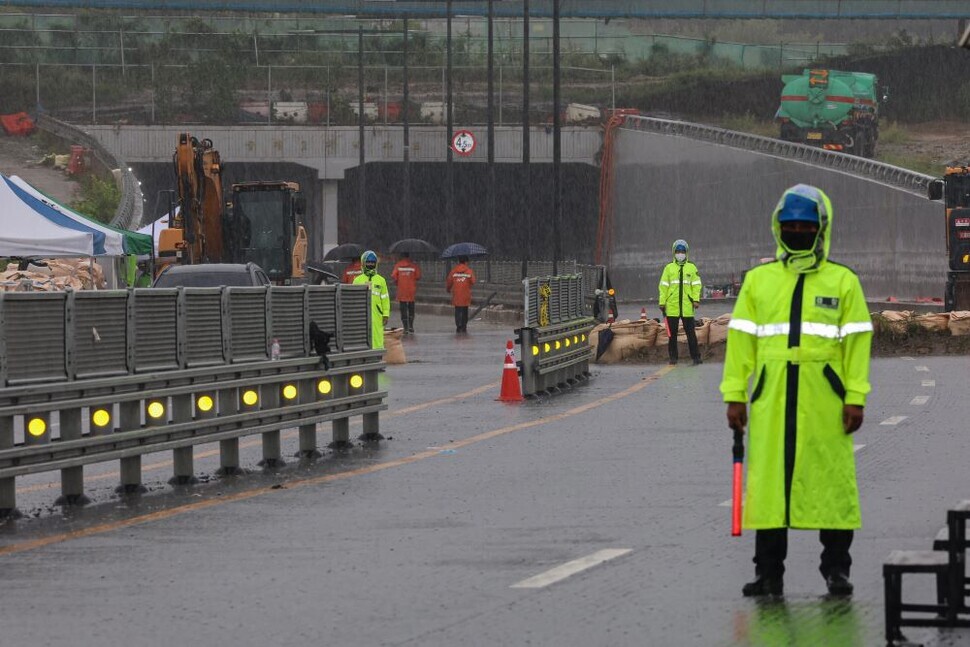
The flooding of the Gungpyeong No. 2 Underpass on Saturday in the Osong township of Cheongju, North Chungcheong Province, bore many similarities to an incident last September involving the flooding of an underground parking garage in Pohang, North Gyeongsang Province.
In the Osong case, around 60 tons of water rushed into the tunnel after the collapse of a temporary embankment at the nearby Miho River Bridge; within two to three minutes, the tunnel was completely inundated.
In the Pohang case, seven residents of an apartment building lost their lives when water from the neighboring Naeng Stream spilled over and rushed into the parking garage, which had no shutters installed to prevent water from flooding in.
Prior to Osong, the recent underpass disaster occurred in 2020, when the Choryang Underpass in Busan was flooded due to heavy rains, resulting in the deaths of three people.
But even the precedents of these disasters were unable to stop similar ones from occurring.
After the incident in Busan, the Ministry of the Interior and Safety moved later that year to designate 145 underpasses as posing flood risks and install barriers. The Osong underpass was actually categorized at the time as “safe.”
A Ministry of the Interior and Safety official explained, “There was no history of flooding [with the Osong underpass], and since the lanes were not especially narrow, we deemed it to be safe.”
Another consideration impacting that decision was the height of the nearby embankment — but a bridge construction effort resulted in a temporary embankment that ended up crumbling. The tragedy happened at a moment when the city of Cheongju had received a separate subsidy from the Ministry of the Interior and Safety last month to budget for barrier facilities.
The possibility of heavy rains causing the river to spill over and flood underground locations has not been considered in the protocols. Even the recovery efforts have ended up delayed due to budget constraints and other factors.
Residents in Pohang were left indignant when it took until June 2023 to begin recovery efforts for the Naeng Stream area, which was affected by Typhoon Hinnamnor last year.
“Budgeting for safety should be the top priority, but it’s been the lowest priority, and these kinds of problems keep happening as a result,” said Kong Ha-sung, a professor of fire prevention studies at Woosuk University.
“There were measures in place for the underpass with the installation of automatic barrier facilities and the adoption of a remote closure system, but they weren’t implemented quickly,” he explained.
Situations where the division of labor and responsibilities between central offices and local governments is unclear have also been identified.
A map of river inundation risks nationwide was developed by the Ministry of Environment for flood prevention purposes, but it has not been put to proper use. According to that map, the Osong underpass is classified as a low-lying area that could end up inundated by 5 meters or more due to flood waters.
An Environment Ministry official explained, “The map is to be used by local governments as a reference for evacuation sites and flood prevention.”
Other countries also have flood maps, but South Korea’s categorization of them as being “for reference” means that few local governments actually use them on the ground.
“Currently, the district office is on the front lines in terms of responsibility for the disaster, but there’s no overall leadership for disaster management,” said Cho Won-cheol, director of the Yonsei University Disaster Prevention and Safety Management Center.
“We need an integration of functions to oversee these things, but the National Assembly hasn’t made the laws for that,” he added.
By Park Su-ji, staff reporter; Jang Na-rye, staff reporter; Yoon Yeon-jeong, staff reporter
Please direct questions or comments to [english@hani.co.kr]
Editorial・opinion
![[Column] Welcome to the president’s pity party](https://flexible.img.hani.co.kr/flexible/normal/500/300/imgdb/original/2024/0515/3917157400447943.jpg "[Column] Welcome to the president’s pity party") [Column] Welcome to the president’s pity party
[Column] Welcome to the president’s pity party![[Editorial] Korea must respond firmly to Japan’s attempt to usurp Line](https://flexible.img.hani.co.kr/flexible/normal/500/300/imgdb/original/2024/0514/2317156736305813.jpg "[Editorial] Korea must respond firmly to Japan’s attempt to usurp Line") [Editorial] Korea must respond firmly to Japan’s attempt to usurp Line
[Editorial] Korea must respond firmly to Japan’s attempt to usurp Line- [Editorial] Transfers of prosecutors investigating Korea’s first lady send chilling message
- [Column] Will Seoul’s ties with Moscow really recover on their own?
- [Column] Samsung’s ‘lost decade’ and Lee Jae-yong’s mismatched chopsticks
- [Correspondent’s column] The real reason the US is worried about Chinese ‘overcapacity’
- [Editorial] Yoon’s gesture at communication only highlights his reluctance to change
- [Editorial] Perilous stakes of Trump’s rhetoric around US troop pullout from Korea
- [Guest essay] Preventing Korean Peninsula from becoming front line of new cold war
- [Column] The state is back — but is it in business?
Most viewed articles
- 1[Column] Welcome to the president’s pity party
- 2[Editorial] Transfers of prosecutors investigating Korea’s first lady send chilling message
- 3Could Korea’s Naver lose control of Line to Japan?
- 4[Editorial] Korea must respond firmly to Japan’s attempt to usurp Line
- 5Major personnel shuffle reassigns prosecutors leading investigations into Korea’s first lady
- 6Second suspect nabbed for gruesome murder of Korean in Thailand, 1 remains at large
- 7[Column] Will Seoul’s ties with Moscow really recover on their own?
- 8US has always pulled troops from Korea unilaterally — is Yoon prepared for it to happen again?
- 9Korea cedes No. 1 spot in overall shipbuilding competitiveness to China
- 10[Photo] Korean students protest US complicity in Israel’s war outside US Embassy