hankyoreh
Links to other country sites 다른 나라 사이트 링크
Canal model dredging confirmed in Four Rivers project
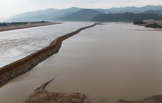
An examination of construction sites by the Hankyoreh has confirmed that the dredging efforts currently taking place around the country as part of the Four Major Rivers Restoration Project follow a “canal model” that would allow the future passage of boats, rather than a natural river servicing model.
The examination, carried out Sunday by the Hankyoreh based on riverbed section drawings in the revised “Nakdong River Basic Plan,” showed that “canal-model” dredging is currently taking place. Through this model of dredging, the riverbed is sculpted into broad, flat trapezoids to allow the passage of boats.
The Nakdong River Basic plan has the riverbed near Mungyeong undergoing reconstruction into a canal-model section at the Nakdong River estuary dike, a zone in the Grand Korean Waterway plan. This revised plan includes alterations made following the formulation of the Four Major Rivers Restoration Project master plan. The Busan Regional Construction Management Administration gave notification of the changes on July 2 of last year.
According to the plan, the Gyeongcheondae Beach riverbed section in Sangju, North Gyeongsang Province (Zone 548), will be broad and flat after the project. This section, which currently lies at an oblique angle from the sand on the waterfront, is to be sculpted cleanly into a trapezoid form with a width of 320 meters and a depth of 10 meters. Gyeongcheondae’s beach, considered one of the most beautiful sights on the Nakdong River, will disappear as a result. In addition, the same form of trapezoidal dredging is taking place all along the main course of the Nakdong River, including the Haepyeong Wetland in Gumi and Haman Weir in Changnyeong County, South Gyeongsang Province.
To date, the Lee Myung-bak administration has claimed that the Four Major Rivers effort is not a preliminary stage to the Grand Korean Waterway and that it involves natural river dredging conforming to the methods of a national river servicing project. It has argued that canal dredging is structured around flattening out the riverbed to allow easy passage for cargo vessels, while natural river dredging does not allow the passage of boats because the waterfront and riverbed are dug too steeply.
Indeed, in a December 2008 official press release about the Four Major Rivers Restoration Project, the Ministry of Land, Transport and Maritime Affairs (MLTM) stated that a grand waterway would involve “excavating the central riverbed for the passage of vessels,” while the Four Major Rivers Restoration Project effort involved “clearing away areas where soil has accumulated excessively in order to prevent flooding.”
In contrast to this explanation by the Lee administration, however, an inspection of the current construction sites showed that a canal-model dredging effort is taking place, with the central bed of the rivers being excavated according to the revised basic plan.
A construction official at Nakdong River Zone 34, near Gyeongcheondae, said, “We are dredging according to the design plan, and the riverbed section will be shaped into a trapezoid.”
The Hankyoreh’s examination of the plan for the zone in question also confirmed that the riverbed sections for all zones were being altered into trapezoid forms.
An expert who has taken part in the Four Major Rivers Restoration Project also gave statements along a similar vein.
“If they are not creating a canal, then they simply have to adjust the water level in preparation for a flood, so there is no reason to do canal-model trapezoidal dredging,” said the expert. “They are saying they have abandoned the canal, but the construction techniques still follow preparations for a canal.”
Kwandong University Civil Engineering Professor Park Chang-keun said, “Trapezoidal dredging has been taking place in all zones of the project, on the Han, Geum, and Yeongsan Rivers as well as the Nakdong, in preparation for a canal.”
In response, Ahn Si-kwon, head of the policy oversight team at the Four Major Rivers Restoration Project headquarters, explained, “The construction plans are being followed in consideration of the degree of riverbed accumulation, meaning, upstream, midstream, and downstream, so there may be some differences in the section drawing according to the site location.”
“Essentially, however, it has nothing to do with a canal,” Ahn added.
Please direct questions or comments to [englishhani@hani.co.kr]
Editorial・opinion
![[Column] Park Geun-hye déjà vu in Yoon Suk-yeol](https://flexible.img.hani.co.kr/flexible/normal/500/300/imgdb/original/2024/0424/651713945113788.jpg "[Column] Park Geun-hye déjà vu in Yoon Suk-yeol") [Column] Park Geun-hye déjà vu in Yoon Suk-yeol
[Column] Park Geun-hye déjà vu in Yoon Suk-yeol![[Editorial] New weight of N. Korea’s nuclear threats makes dialogue all the more urgent](https://flexible.img.hani.co.kr/flexible/normal/500/300/imgdb/original/2024/0424/7317139454662664.jpg "[Editorial] New weight of N. Korea’s nuclear threats makes dialogue all the more urgent") [Editorial] New weight of N. Korea’s nuclear threats makes dialogue all the more urgent
[Editorial] New weight of N. Korea’s nuclear threats makes dialogue all the more urgent- [Guest essay] The real reason Korea’s new right wants to dub Rhee a founding father
- [Column] ‘Choson’: Is it time we start referring to N. Korea in its own terms?
- [Editorial] Japan’s rewriting of history with Korea has gone too far
- [Column] The president’s questionable capacity for dialogue
- [Column] Are chaebol firms just pizza pies for families to divvy up as they please?
- [Column] Has Korea, too, crossed the Rubicon on China?
- [Correspondent’s column] In Japan’s alliance with US, echoes of its past alliances with UK
- [Editorial] Does Yoon think the Korean public is wrong?
Most viewed articles
- 1[Column] Park Geun-hye déjà vu in Yoon Suk-yeol
- 2N. Korean hackers breached 10 defense contractors in South for months, police say
- 3Will NewJeans end up collateral damage in internal feud at K-pop juggernaut Hybe?
- 4[Cine feature] A new shift in the Korean film investment and distribution market
- 5[Editorial] Japan’s rewriting of history with Korea has gone too far
- 6[Column] ‘Choson’: Is it time we start referring to N. Korea in its own terms?
- 7Kim Jong-un expressed ‘satisfaction’ with nuclear counterstrike drill directed at South
- 8[Editorial] New weight of N. Korea’s nuclear threats makes dialogue all the more urgent
- 9[Column] The clock is ticking for Korea’s first lady
- 10Senior doctors cut hours, prepare to resign as government refuses to scrap medical reform plan