hankyoreh
Links to other country sites 다른 나라 사이트 링크
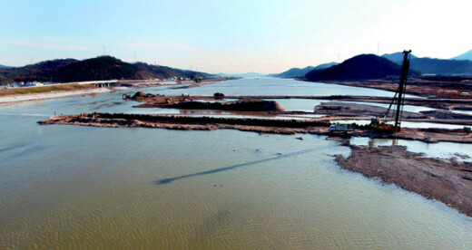
Four Rivers project has created navigable ship canals, study confirms
By Cho Hong-sup, Environment Correspondent
A joint study has confirmed that with the completion of the Four Major Rivers Restoration Project, 3,000-ton vessels will be able to sail the Nakdong and Yeongsan rivers, while 700-ton vessels will be able to sail the Han and Geum rivers. Moreover, the Yeongju Dam’s secured water sources on the Nakdong River, which does not lack water, and the expansion of sea dike sluice gates on the Nakdong River Estuary Barrage was very possibly made with a canal in mind.
These findings seem to confirm long-denied concerns that the Lee Myung-bak administration’s Four Major Rivers Restoration Project is actually the preliminary stage of the rejected Grand Korean Waterway.
The Hankyoreh conducted a study along with the Korea Rivers Society and Professors’ Organization for Movement against Grand Korean Canal, consisting of over 2,500 university professors opposed to the Grand Korean Waterway. The study analyzed the “Four Rivers Master Plan” drawn up by the Ministry of Land, Transport and Maritime Affairs and the depth standards for inland waterborne transportation set out by the World Association for Waterborne Transport Infrastructure (PIANC). The findings confirmed that the Four Major Rivers Restoration Project’s waterways and water supply, the key elements of a canal, meet the PIANC standards for inland waterborne transportation.
The Lee Myung-bak administration has claimed both that the Four Major Rivers Restoration Project would not link the four major rivers, and that the constructed waterways’ physical conditions were not right for a canal, citing water depth, waterway width and a lack of straight courses.
The Hankyoreh’s analysis of the plan, however, revealed that the Four Major Rivers Restoration Project’s construction has produced waterways suitable for vessel transport on most parts of the four major rivers.
According to PIANC, a water depth of 3.3 meters or more can support a barge of 3,000 tons, and 2 meters or more can support a barge of 700 tons. The lowest depth of the Nakdong River from the Nakdong River Estuary Barrage to the Chilgok Dam in Gumi, North Gyeongsang Province is 6 meters, and to the confluence with the Yeong River in Sangju it is 4 meters, so it can carry a large barge 110m long, 11m wide and 3,000t in displacement.
On the Yeongsan River, too, from the estuary barrage to the confluence with the Gwangju Stream, the minimum water depth is 5m, allowing for a 3,000t vessel to navigate it. On the Han River, the minimum depth from the Paldang Dam to the confluence with the Seom River is 3m, and the minimum depth of the Geum River from the estuary barrage to the Geumnam Dam in Sejong City is 2.5m, allowing a barge 70m long, 9m wide and 700t in displacement to navigate those rivers under its own power.
The width of the low waterway is 360-560m on the Nakdong River from the estuary to the confluence with the Yeong River in Sangju, and more than 200-300m on the other rivers, allowing vessels to navigate them without a problem.
Due to Four Major Rivers Restoration Project construction, the low waterway on the Nakdong River from Gangjeong Dam to Chilgok Dam, previously 170m, would be widened to 560m. Likewise, the low waterway width of the Chilgokk-Gumi section would be expanded from 190m to 500m, the Gumi to Nakdan section would be expanded from 200m to 500m, and the Nakdan to Sangju section would be expanded from 150m to 360m, and the Sangju to Yeong River confluence would be expanded from 190m to 430m.
The water depth on the Rhine-Main-Danube Canal, the model for the Great Korean Canal, is 4m and the low waterway width is 55m.
Experts previously voiced criticism that it was dredging the entirety of the four rivers in the shape of a ladder, as is the case with canals. In response, the Ministry of Land, Transport and Maritime Affairs explained through an Aug. 16 press release that because the minimum water depth on major sections of the Four Rivers was just 0.5-3m and the low waterway width differed from section to section, freight transport on the rivers was impossible.
The Korea Rivers Society said that in the Lee administration’s long-term plan for water resources, it plans to obtain 650 million cubic meters of water through large scale dredging and weir construction, and another 299 million cubic meters of water through construction of the Yeongju Dam, despite its forecast that the Nakdong River would have over 11 million cubic meters of water in 2011. In this case, the evidence seems to say that the water use is for a canal.
Park Chang-geun, civil engineering professor of Kwandong University, said, “After the canal-use waterways and water reserves are secured, it is possible to then build sluice gates through a simple change to the movable weirs.” Park went on to say, “If the administration also build docks and logistics complexes through Special Law on Hydrophilic Areas, the Four Major Rivers Restoration Project would have most of what it takes to be a preparation project for a canal.”
The Korea Rivers Society and Professors’ Organization for Movement against Grand Korean Canal plan to submit an open document to Cheong Wa Dae (the presidential office in South Korea or Blue House) and the Ministry of Land, Transport and Maritime Affairs that includes the suspicions that link the Four Rivers to canal construction.
Please direct questions or comments to [englishhani@hani.co.kr]
Editorial・opinion
![[Guest essay] Preventing Korean Peninsula from becoming front line of new cold war](https://flexible.img.hani.co.kr/flexible/normal/500/300/imgdb/original/2024/0507/7217150679227807.jpg "[Guest essay] Preventing Korean Peninsula from becoming front line of new cold war") [Guest essay] Preventing Korean Peninsula from becoming front line of new cold war
[Guest essay] Preventing Korean Peninsula from becoming front line of new cold war![[Column] The state is back — but is it in business?](https://flexible.img.hani.co.kr/flexible/normal/500/300/imgdb/original/2024/0506/8217149564092725.jpg "[Column] The state is back — but is it in business?") [Column] The state is back — but is it in business?
[Column] The state is back — but is it in business?- [Column] Life on our Trisolaris
- [Editorial] Penalties for airing allegations against Korea’s first lady endanger free press
- [Editorial] Yoon must halt procurement of SM-3 interceptor missiles
- [Guest essay] Maybe Korea’s rapid population decline is an opportunity, not a crisis
- [Column] Can Yoon steer diplomacy with Russia, China back on track?
- [Column] Season 2 of special prosecutor probe may be coming to Korea soon
- [Column] Park Geun-hye déjà vu in Yoon Suk-yeol
- [Editorial] New weight of N. Korea’s nuclear threats makes dialogue all the more urgent
Most viewed articles
- 1Behind-the-times gender change regulations leave trans Koreans in the lurch
- 2South Korean ambassador attends Putin’s inauguration as US and others boycott
- 3Family that exposed military cover-up of loved one’s death reflect on Marine’s death
- 4Yoon’s broken-compass diplomacy is steering Korea into serving US, Japanese interests
- 5[Guest essay] Preventing Korean Peninsula from becoming front line of new cold war
- 6Marines who survived flood that killed colleague urge president to OK special counsel probe
- 7Japan says its directives were aimed at increasing Line’s security, not pushing Naver buyout
- 8Yoon’s revival of civil affairs senior secretary criticized as shield against judicial scrutiny
- 9Amid US-China clash, Korea must remember its failures in the 19th century, advises scholar
- 10Lee Jung-jae of “Squid Game” named on A100 list of most influential Asian Pacific leaders