hankyoreh
Links to other country sites 다른 나라 사이트 링크
S. Korea shares nautical charts of Han River estuary with N. Korea
Nautical charts have been prepared that will enable South and North Korean vessels to navigate the Han River and Imjin River estuaries. Access to the estuaries has been restricted for 65 years, since the Korean Armistice Agreement was signed in 1953, but this will open a maritime route that can be freely used by ships from both sides.
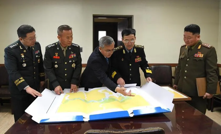
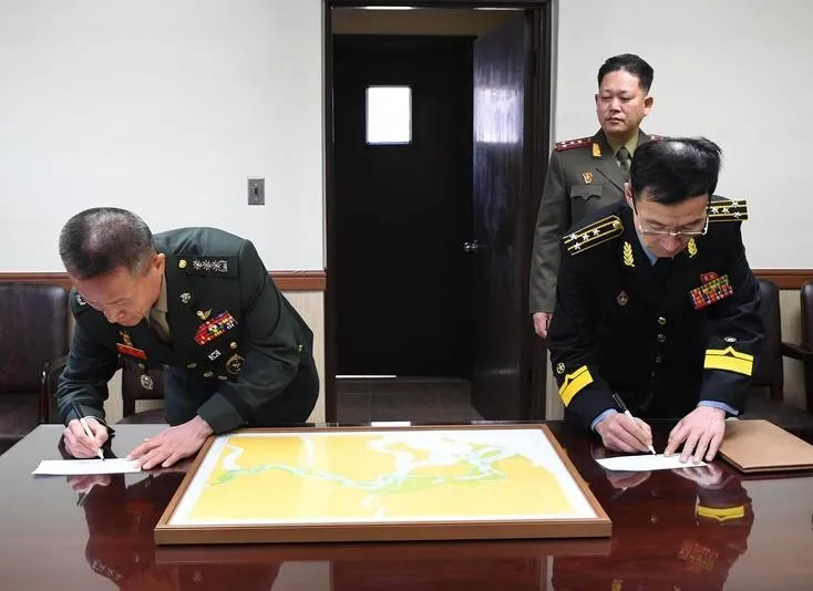
South Korea’s Ministry of National Defense (MND) announced that it had sent the North Korean military on Jan. 30 nautical charts it had composed based on the findings of a joint inter-Korean hydrographic survey carried out at the end of 2018 along with a report on the survey’s findings. The charts were delivered during a working-level meeting between the South and North Korean military officials that was held for 35 minutes, beginning at 10 am, in the meeting room of the Military Armistice Commission (MCA) in the Joint Security Area (JSA) of the DMZ in Panmunjom.
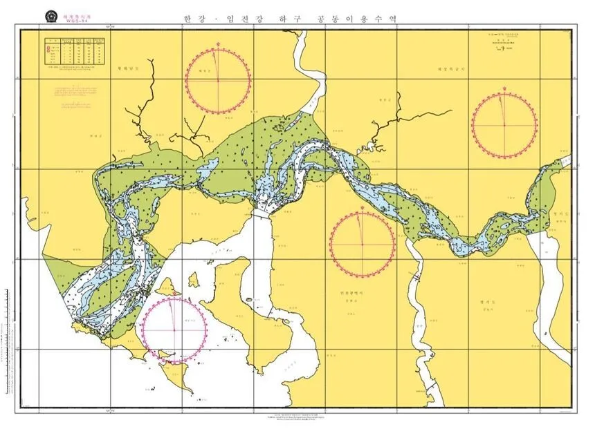
The charts contain information necessary for shared use of the waters by North and South Korean vessels, including water depth, the coastline and submerged rocks. The Han River Estuary is a 70km area that spans from the northeast end of Gimpo Peninsula to the southwest end of Kyodong-do in South Korea, and from Imhan-ri in Panmunjom, Kaesong to Haenam-ri in Yonan County, South Hwanghae Province in North Korea. Under the Armistice Agreement, private vessels from both Koreas are granted free passage in the estuary.
Regarding the meeting between military officials from both Koreas on this day, the MND stated that “an agreement was reached on a number of practical issues related to freedom of navigation for private vessels in the Han River Estuary. It was agreed that free passage in the estuary for private vessels will be permitted on a trial basis from Apr. 1, in accordance with the provisions of the September 19 military agreement, and that this will be gradually expanded in stages.”
The statement continued, “This creates an opportunity for private vessels, which have been restricted from using the Han River Estuary over the past 65 years since the signing of the Armistice Agreement, to once again enjoy free movement in these waters. This is a meaningful joint achievement for North and South Korea.”
A total of five South Korean representatives took part in the working level meeting including Cho Yong-geun, North Korea Policy Chief (Army Colonel) at the Ministry of National Defense, Colonel Yoon Chang-hee, the South Korean head of the Joint Survey Team and Hwang Jun, head of the Waterways Investigation Team at the Ministry of Maritime Affairs and Fisheries. Five North Korean representatives were also present at the meeting including Senior Army Colonel Ham In-sop and Senior Naval Colonel Oh Myong-chol, the North Korean head of the Joint Investigation Team.
By Noh Ji-won, staff reporter
Please direct comments or questions to [english@hani.co.kr]

Editorial・opinion
![[Correspondent’s column] Coupang’s game in Washington follows familiar pattern](https://flexible.img.hani.co.kr/flexible/normal/500/300/imgdb/original/2025/1226/8217667391873536.jpg "[Correspondent’s column] Coupang’s game in Washington follows familiar pattern") [Correspondent’s column] Coupang’s game in Washington follows familiar pattern
[Correspondent’s column] Coupang’s game in Washington follows familiar pattern![[Editorial] Coupang’s attempt to hide behind US won’t win back Korean consumers](https://flexible.img.hani.co.kr/flexible/normal/500/300/imgdb/original/2025/1226/1817667387971465.jpg "[Editorial] Coupang’s attempt to hide behind US won’t win back Korean consumers") [Editorial] Coupang’s attempt to hide behind US won’t win back Korean consumers
[Editorial] Coupang’s attempt to hide behind US won’t win back Korean consumers- Coupang under fire for possible obstruction of investigation into its customer data leak
- [Editorial] Coupang founder’s contempt for workers, customer security knows no bounds
- [Column] Confessions of a Coupang-holic
- [Editorial] Kim Bom-suk’s arrogance on full display in boycott of Coupang leak hearing
- [Editorial] The facts of Yoon’s insurrection are clear — justice cannot be further delayed
- [Column] Trump destroys government
- [Column] A post-Western world approaches
- [Column] Offshore balancing, or carving out spheres of influence?
Most viewed articles
- 1Korea to trial next-gen train capable of sub-2-hour Seoul-Busan trip starting 2030
- 2Kim Jong-un’s hidden motive in criticizing South Korea’s nuclear submarine push
- 3[Editorial] Coupang’s attempt to hide behind US won’t win back Korean consumers
- 4Coupang under fire for possible obstruction of investigation into its customer data leak
- 5[Correspondent’s column] Coupang’s game in Washington follows familiar pattern
- 6Real-life heroes of “A Taxi Driver” pass away without having reunited
- 7Moon Jae-in renews call for end-of-war declaration, peace treaty on Korean Peninsula
- 8Chang Chun-ha’s family hopes to know truth of his death after 37 years
- 9Chinese money flooding into South Korean companies
- 10Russian architect personally witnessed Empress Myeongseong’s assassination by Japanese ronin, accoun