hankyoreh
Links to other country sites 다른 나라 사이트 링크
Shots exchanged along “powder keg” of two Koreas’ western sea boundary
The disputed maritime demarcation line off Korea’s western coast is drawing attention again after a North Korean merchant ship crossed the Northern Limit Line (NLL) early on Monday and warning shots were exchanged between the two sides.
Regarding this incident, South Korea’s Joint Chiefs of Staff and North Korea’s People's Army General Staff each claimed that the other side crossed the NLL and made the first provocation, in response to which they then proceeded to fire warning shots as a countermeasure.
However, the two Koreas hold very different views on where the maritime border actually lies.
Back in 1953, when the Armistice Agreement for the Korean War was signed on July 27, the signatories only agreed on the Military Demarcation Line on land, but a maritime border was yet to be finalized.
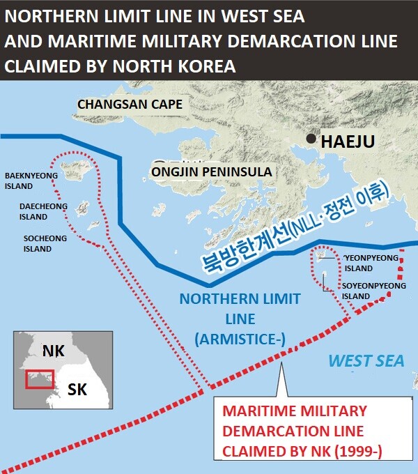
That year on Aug. 30, the UN commander unilaterally drew up the NLL based on a midline between five islands in the West Sea and North Korean territory to prevent the possibility of accidental maritime armed clashes.
Since then, South Korea has defined the NLL in the West Sea as a “de-facto maritime border between the two Koreas” and the waters south of the NLL as being under its jurisdiction. In particular, South Korean conservatives see the NLL as a “territorial line protected by blood and death.”
North Korea, on the other hand, does not recognize the NLL as a maritime border.
Only after a clash near Yeonpyeong Island in June 1999 did North Korea begin taking the NLL more seriously. On Sept. 2 of that year, the North unilaterally declared a different maritime demarcation line in the West Sea through a special communiqué by the Korean People’s Army General Staff.
According to this North Korean version of the NLL, most of the waters south of Yeonpyeong Island would be considered North Korean waters, while the five islands in the West Sea would also fall under North Korean maritime territory.
In reality, the North Korean NLL was drawn much further south than South Korea's NLL, effectively voiding the latter.
During the fourth general-level talks in May 2006, North Korea proposed establishing a new maritime military demarcation line located somewhere halfway between 12 nautical miles of North Korean territory and the NLL. However, South Korea did not accept the proposal, fearing the NLL would lose its meaning.
Then, during the inter-Korean summit in October 2007, the two Koreas agreed on the major principle of indirectly dealing with the NLL issue by establishing a zone for peace and cooperation in the West Sea.
However, talks on the maritime peace zone project eventually broke down as Lee Myung-bak took office as South Korea’s president in 2008. Instead, South Korea returned to its original position of defending its version of the NLL and punishing provocations.
Efforts to resolve the issue once again resumed in 2018, when then-President Moon Jae-in and North Korean leader Kim Jong-un signed the Sept. 19 Comprehensive Military Agreement. Through the agreement, both sides agreed to turn the NLL into a zone of peace and to work on preventing accidental military clashes.
The area surrounding the NLL in the waters off the peninsula’s western coast is referred to as the “powder keg” of the Korean Peninsula. This is because of the many naval confrontations that have taken place near NLL waters, including the two naval battles over Yeonpyeong, once in June 1999 and another in June 2002, the Daecheong incident of November 2009, and the shelling of Yeonpyeong Island in November 2010.
By Kwon Hyuk-chul, staff reporter
Please direct questions or comments to [english@hani.co.kr]

Editorial・opinion
![[Editorial] Intensifying US-China rivalry means Seoul must address uncertainty with Beijing sooner than later](https://flexible.img.hani.co.kr/flexible/normal/500/300/imgdb/original/2024/0517/8117159322045222.jpg "[Editorial] Intensifying US-China rivalry means Seoul must address uncertainty with Beijing sooner than later") [Editorial] Intensifying US-China rivalry means Seoul must address uncertainty with Beijing sooner than later
[Editorial] Intensifying US-China rivalry means Seoul must address uncertainty with Beijing sooner than later![[Column] When ‘fairness’ means hate and violence](https://flexible.img.hani.co.kr/flexible/normal/500/300/imgdb/original/2024/0516/7417158465908824.jpg "[Column] When ‘fairness’ means hate and violence") [Column] When ‘fairness’ means hate and violence
[Column] When ‘fairness’ means hate and violence- [Editorial] Yoon must stop abusing authority to shield himself from investigation
- [Column] US troop withdrawal from Korea could be the Acheson Line all over
- [Column] How to win back readers who’ve turned to YouTube for news
- [Column] Welcome to the president’s pity party
- [Editorial] Korea must respond firmly to Japan’s attempt to usurp Line
- [Editorial] Transfers of prosecutors investigating Korea’s first lady send chilling message
- [Column] Will Seoul’s ties with Moscow really recover on their own?
- [Column] Samsung’s ‘lost decade’ and Lee Jae-yong’s mismatched chopsticks
Most viewed articles
- 1[Editorial] Transfers of prosecutors investigating Korea’s first lady send chilling message
- 2[Column] US troop withdrawal from Korea could be the Acheson Line all over
- 3Xi, Putin ‘oppose acts of military intimidation’ against N. Korea by US in joint statement
- 4[Editorial] Intensifying US-China rivalry means Seoul must address uncertainty with Beijing sooner t
- 5[Exclusive] Unearthed memo suggests Gwangju Uprising missing may have been cremated
- 6‘Shot, stabbed, piled on a truck’: Mystery of missing dead at Gwangju Prison
- 7[Column] When ‘fairness’ means hate and violence
- 8China calls US tariffs ‘madness,’ warns of full-on trade conflict
- 9[Editorial] Yoon must stop abusing authority to shield himself from investigation
- 10China, Russia put foot down on US moves in Asia, ratchet up solidarity with N. Korea