hankyoreh
Links to other country sites 다른 나라 사이트 링크
The antitank barricades that dot the landscape in border towns near DMZ
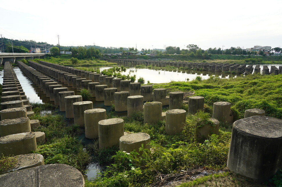
The most prominent military structures on the border region in Gyeonggi Province are the barbed-wire fences along the Han River and the antitank structures built along the roads and waterways. After the experience of being left defenseless against People’s Army forces with Soviet-made T-34 tanks in the early stages of the Korean War in 1950, the South Korean military went to work after the armistice busily setting up antitank barricades and dragon’s teeth” on roads and rivers. With the likelihood of total war shrinking since the 2000s, local governments are now demanding that the dragon’s teeth and other antitank structures be removed.
The zenith of antitank construction came when the new city of Ilsan was built in the early 1990s. During a July 1994 extraordinary session of the National Assembly, then Minister of National Defense Lee Byung-tae infuriated Ilsan residents when he announced that the “new cities on the periphery of Greater Seoul will be used as barriers to block the southern advancement of North Korea in the event of an emergency.” That September, a memorandum of agreement on a military readiness plan for Ilsan New City was made public. Drafted on Aug. 31, 1990, between Army Chief of Staff Lee Jin-sam and Korea Land Development Corporation (KLDC) President Lee Sang-hee, the document includes plans for narrowing south-north roads and broadening east-west ones, arranging apartments and other structures horizontally from east to west to suit military operations, and using easily dismantled plywood for walls between units to allow strongholds to be established in an emergency situation. Guidelines for a “stronghold establishment design concept” for Ilsan sent to the KLDC president by the Army’s Jayu Motorway project team called for positioning at least 60% of all apartments in a horizontal direction and allowing stronghold adaptation for athletic fields, parks, and even children’s playgrounds.
In contrast with the South’s traumatizing experience with tanks, the North had seen its entire territory obliterated in attacks by US fighter aircraft, and its response strategy was to build large-scale defense positions underground.
After building large tunnels around the Armistice Line during the war, North Korea began pursuing underground positioning of military facilities in earnest with Kim Il-sung’s 1962 strategy of “fortifying the entire national territory.” Four North Korean tunnels discovered south of the Military Demarcation Line (MDL) between 1974 and 1990 were part of this. The tunnels’ only entrances are on the North Korean side, but South Korean authorities fashioned “indirect shafts” dug to locate the tunnels into a sight for visiting tourists. Symbols of the anti-communist spirit, the tunnels also served as a pretext for fortifying the area around the MDL.
In a paper titled “A Study of the Development of Tunnels into ‘Cold War Spectacles’ during the 1970s,” Jeon Won-geun, a visiting researcher at the Seoul National University Institute for Social Development and Policy Research, wrote, “As an end to the national division system and Cold War is sought, Cold War-era spectacles like the tunnels will need to be reconfigured in different ways.”
“As we begin to question the politics of security and the vicious cycle of fear, the tunnels will emerge as an open spectacle within a more diverse process of meaning,” Jeon wrote.
By Park Kyung-man, North Gyeonggi correspondent
Please direct comments or questions to [english@hani.co.kr]

Editorial・opinion
![[Column] Has Korea, too, crossed the Rubicon on China?](https://flexible.img.hani.co.kr/flexible/normal/500/300/imgdb/original/2024/0419/9317135153409185.jpg "[Column] Has Korea, too, crossed the Rubicon on China?") [Column] Has Korea, too, crossed the Rubicon on China?
[Column] Has Korea, too, crossed the Rubicon on China?![[Correspondent’s column] In Japan’s alliance with US, echoes of its past alliances with UK](https://flexible.img.hani.co.kr/flexible/normal/500/300/imgdb/original/2024/0419/2317135166563519.jpg "[Correspondent’s column] In Japan’s alliance with US, echoes of its past alliances with UK") [Correspondent’s column] In Japan’s alliance with US, echoes of its past alliances with UK
[Correspondent’s column] In Japan’s alliance with US, echoes of its past alliances with UK- [Editorial] Does Yoon think the Korean public is wrong?
- [Editorial] As it bolsters its alliance with US, Japan must be accountable for past
- [Guest essay] Amending the Constitution is Yoon’s key to leaving office in public’s good graces
- [Editorial] 10 years on, lessons of Sewol tragedy must never be forgotten
- [Column] A death blow to Korea’s prosecutor politics
- [Correspondent’s column] The US and the end of Japanese pacifism
- [Guest essay] How Korea turned its trainee doctors into monsters
- [Guest essay] As someone who helped forge Seoul-Moscow ties, their status today troubles me
Most viewed articles
- 1[Column] The clock is ticking for Korea’s first lady
- 2After 2 months of delayed, denied medical care, Koreans worry worst may be yet to come
- 3Samsung barricades office as unionized workers strike for better conditions
- 4[Column] Has Korea, too, crossed the Rubicon on China?
- 5[Correspondent’s column] In Japan’s alliance with US, echoes of its past alliances with UK
- 6Hong Se-hwa, voice for tolerance whose memoir of exile touched a chord, dies at 76
- 7All eyes on Xiaomi after it pulls off EV that Apple couldn’t
- 8US overtakes China as Korea’s top export market, prompting trade sanction jitters
- 9[Editorial] When the choice is kids or career, Korea will never overcome birth rate woes
- 10[Photo] Smile ambassador, you’re on camera