hankyoreh
Links to other country sites 다른 나라 사이트 링크
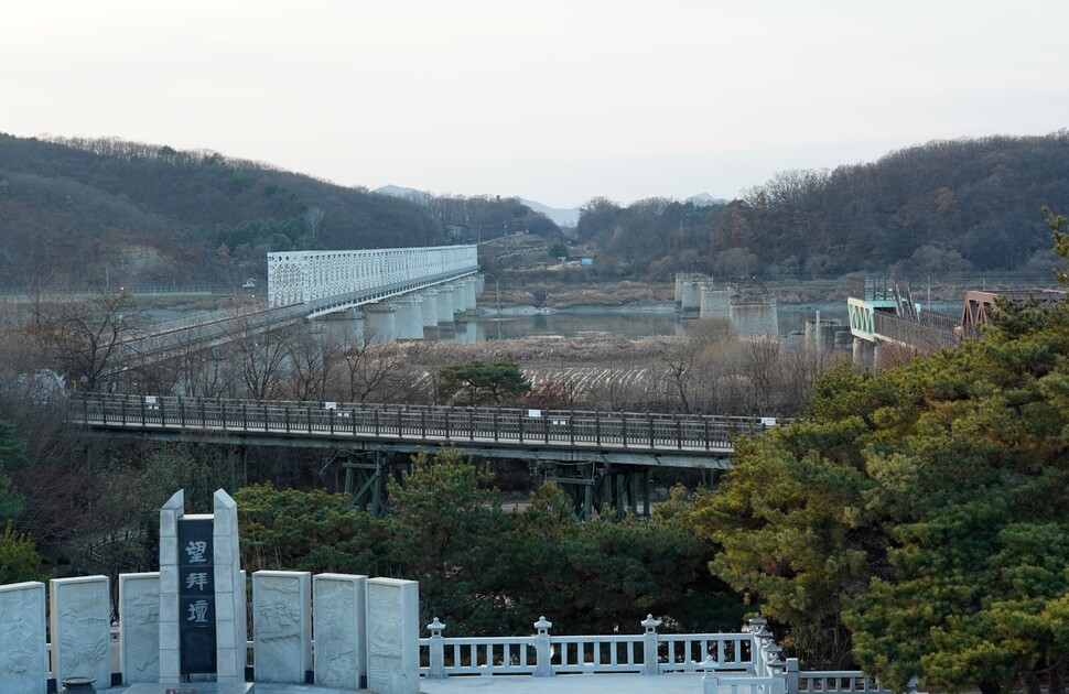
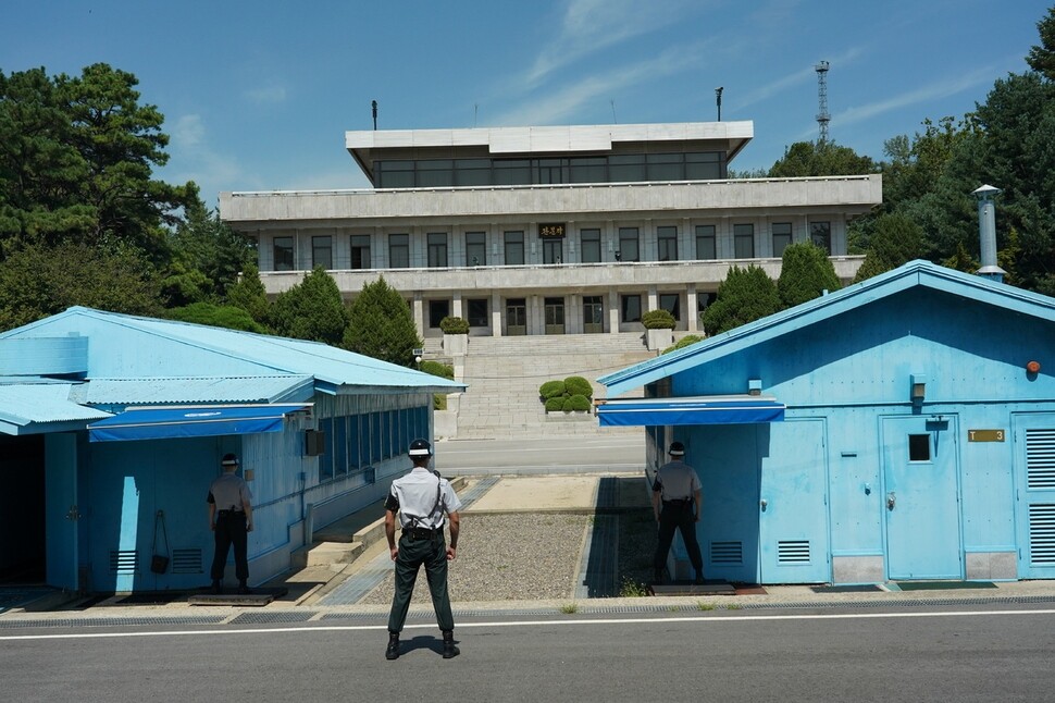
[Reportage] The DMZ: more than a millennium of military conflict
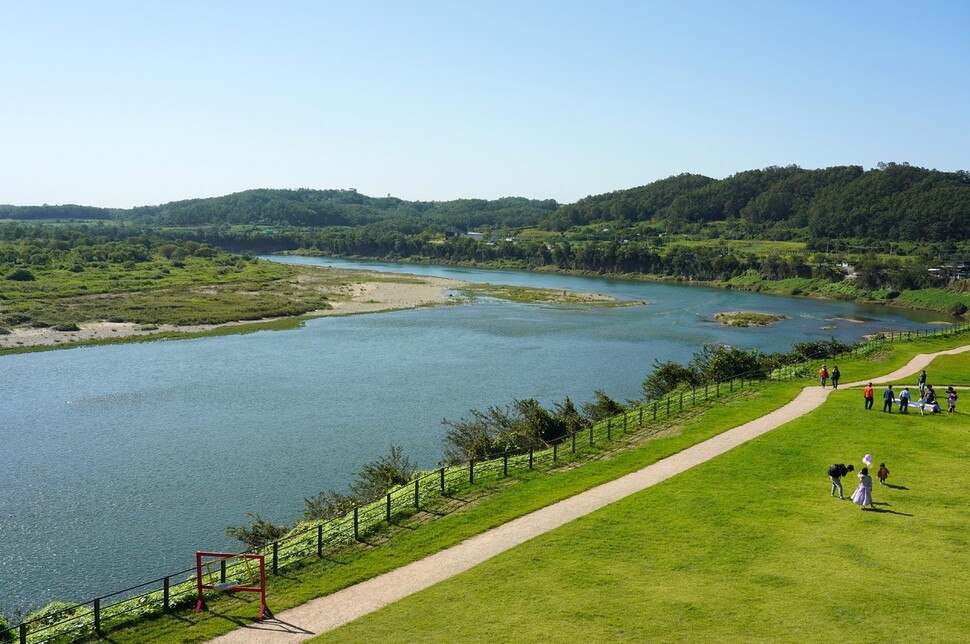
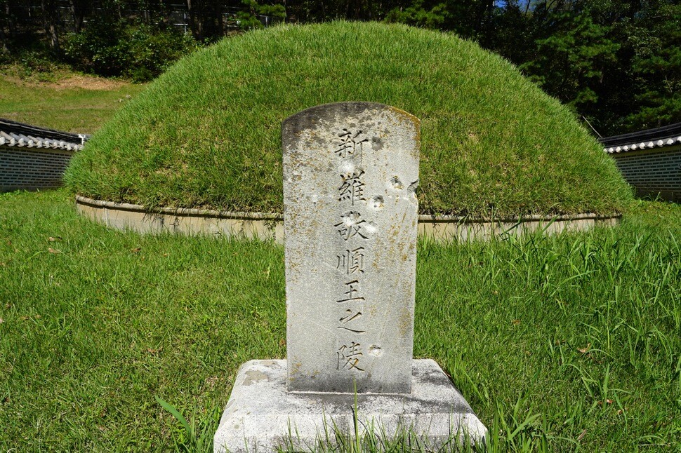
The Imjin River, which forms part of the border between South and North Korea, was also a national border a millennium and a half ago, during the Three Kingdoms Period. For more than a century, it formed the line of conflict between the kingdoms of Goguryeo, Baekje, and Silla. The ruins of fortresses that line the riverbanks, including Horogoru Fortress and Gwanmi Fortress, display traces of battles from those times. The area along the river abounds with historical and cultural resources, including the remains of once-busy ports such as Gorang and Imjin Ferry Landing and the tomb of Gyeongsun, the final ruler of the Silla Dynasty who surrendered his kingdom to Wang Geon, founder of the Goryeo Dynasty. There are also outstanding natural features, such as columnar joints and red-hued cliffs, as well as enough rare plants and animals along the Imjin River in Yeoncheon County, Gyeonggi Province, and in areas along the DMZ in Gangwon Province to be designated as UNESCO biosphere reserves this past June. This has fueled a campaign to have the DMZ itself registered as a UNESCO World Heritage site.
War unfolds along the Imjin River
Horogoru Fortress in Yeoncheon County, built at the confluence of the Imjin and Hantan rivers, is a flatland fortification, but standing there atop a natural basalt bluff on Oct. 8, I was afforded a panoramic view of the rivers below. Along with Eundae and Dangpo, also in Yeoncheon, Horogoru Fortress is regarded as one of the three greatest fortresses of the kingdom of Goguryeo.
The Imjin River basin belonged to Baekje, another polity in the Three Kingdoms Period, until the fourth century. But in 390, King Gwanggaeto of Goguryeo led 40,000 soldiers in attacks on Gwangmi Fortress (presumed to be the fortifications found on Mt. Odu today) and other Baekje fortifications in the area. Gwanggaeto’s ambitions of southern expansion triggered a long war over the Imjin River.
In the year 393, General Jinmu of Baekje was repulsed when he attempted to retake Gwanmi Fortress with an army of 10,000 soldiers. Gwanggaeto continued his advance in 396, capturing 58 Baekje castles and forcing King Asin of Baekje to surrender. King Jangsu used the area that his father Gwanggaeto had acquired around the Imjin River as a staging ground for pushing further south. After capturing the Baekje capital of Hanseong (presently Seoul) in 475, he extended the kingdom’s southern border from Asan Bay (Asan, South Chungcheong Province) in the west to Yeongil Bay (Pohang, North Gyeongsang Province) in the east.
The next time the Imjin River became a strategic stronghold was in 551. After Goguryeo’s defensive positions at Mt. Acha on the Han River collapsed under attack by the coalition forces of Silla and Baekje, Goguryeo pulled back to the Imjin River and set up defensive positions on the northern bank. These fortifications were designed to prevent Silla from pushing north. Now in control of the Han River basin, the armies of Silla advanced as far as the Imjin River but failed to penetrate the robust strongholds that Goguryeo had built there. Silla dug in on the southern bank, and a standoff ensued. The area was pervaded by military tensions for the next century: despite continuing skirmishes, neither side was able to dominate the Imjin River until the fall of Goguryeo in 668.
After seizing Pyongyang, the capital of Goguryeo, in 668, the forces of Tang China marched southward, in violation of their agreement with Silla. The soldiers of Goguryeo congregated at Horogoru Fortress on the Imjin River and fought a desperate battle against the Tang armies with the river at their back. Seven years later, in 675, the Tang forces launched an attack on Silla’s Chiljung Fortress, on the southern bank of the Imjin River, in the hope of opening the way to Hanseong. When this attack faltered, the Tang changed approaches and stationed an army of 200,000 men at Maecho Fortress (presumed to be today’s Daejeon-ri Fortress in Yeoncheon County, Gyeonggi Province), with their supply lines running along the Jo River, at the mouth of the Imjin River. Catching wind of these developments, the Silla troops crushed the logistics base at Cheon Fortress (as Gwanmi Fortress was known in Silla), cutting off the supply line and throwing the Tang forces at Maecho Fortress into confusion. Silla took advantage of this opportunity to maul the Tang army. In 677, two years after its defeat at the Battle of Maecho Fortress, the Tang army moved the Andong Protectorate (the Protectorate General to Pacify the East) that it had established in Pyongyang to Fushun, Liaoning Province, allowing Silla to unify the Korean Peninsula under its control.
The area around the Imjin River in Yeoncheon that was recently named a UNESCO biosphere reserve had already been designated a cultural heritage protection zone by the South Korean government. There are nine cultural sites in the area: Horogoru Fortress, a water spider habitat in Eundae Village, Paleolithic ruins at Jeongok Village, the tomb of King Gyeongsun, the site of Sungui Hall, Dangpo Fortress, Eundae-ri Fortress, the water tower at Yeoncheon Station, and the crematorium of the UN forces at Yeoncheon. Aside from the water tower and the crematorium, all these cultural sites are distributed along the Imjin River and are part of the main area of the biosphere reserve.
A lost kingdom in Cheorwon County
Today, the DMZ runs right down the middle of Cheorwon County in Gangwon Province. Before the Korean War, however, the county was the site of a prosperous town that served as a transportation hub for the Korean Peninsula. But the war erased the history of Old Cheorwon, as the town is known today, and most of its ruins currently lie in the Civilian Control Zone.
Located on the Cheorwon Plains, Old Cheorwon was at the junction of a major prewar railroad line connecting Seoul and Wonsan (the Gyeongwon Line) and a branch line that ran on to Changdo (the Kumgang Line). According to a local paper published by the Japanese colonial authorities in 1938, Cheorwon had a population of 19,693, in 4,269 households. The town had five schools, four banks, 34 government offices, 34 inns, and 61 restaurants. Trade was brisk in the town, which was a distribution center for produce, and by the time of Korea’s liberation from Japanese control in 1945, its population had increased to 37,855.
A fierce ideological conflict raged in Old Cheorwon, with control of the town changing hands several times after liberation. Signs of that conflict can still be seen in various ruins found nearby. Cheorwon Station was a stopover on the Gyeongwon Line, which the Japanese Empire had built to transport war supplies following the Russo-Japanese War; today, all that remains are dilapidated signs and railroad tracks. There used to be eight daily trains on the Kumgang Line, covering the 116.6km from Old Cheorwon to Mt. Kumgang in four and a half hours. Trains on the line were filled with holidaymakers, students on school trips, and workers extracting mineral wealth for the Japanese Empire. Today, the line is in ruins, and only the bridges are left.
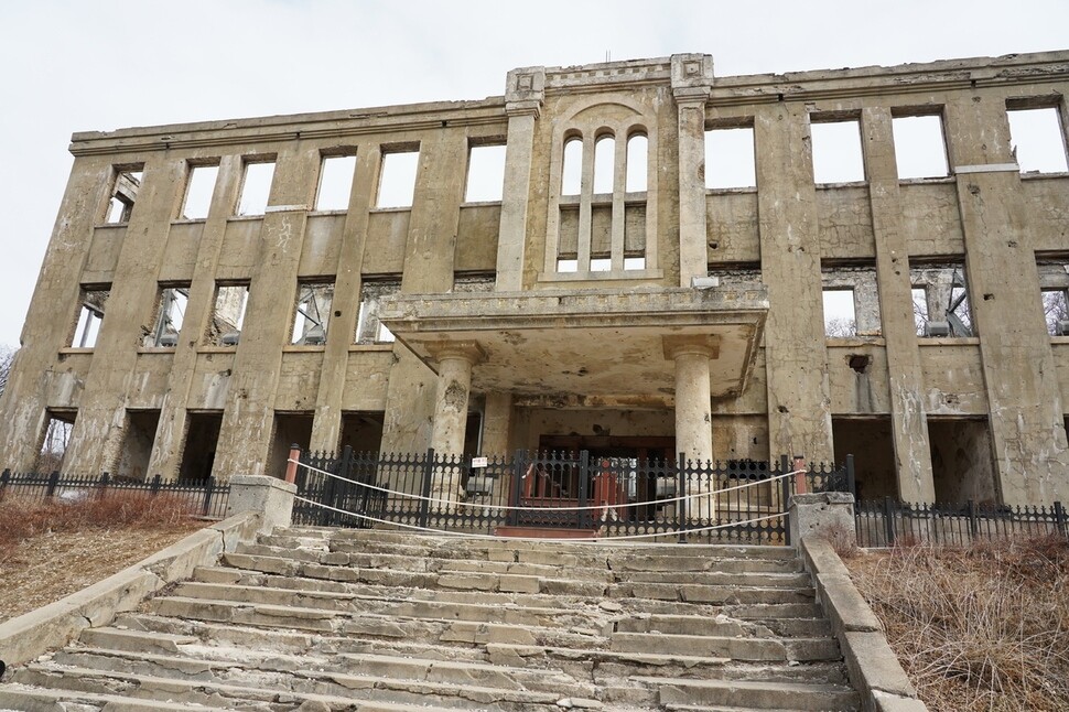
The best preserved of the surviving facilities is the Korean Workers’ Party (WPK) Gangwon Province Headquarters. The building was erected at the highest point in the town of Cheorwon by Soviet troops shortly after Korea’s liberation, with costs paid and labor provided by the locals. The headquarters has become a symbol of Old Cheorwon, the damage caused by bullets and bombs serving as a vivid testimony of the war.
In 1994, the WPK Headquarters famously stood in the background of the music video produced for the song “Dreaming of Balhae” by Seo Taiji, a popular Korean singer at that time. In a research paper titled “About the Ruins: Imagining Peace in Cheorwon,” Seoul National University sociology professor Chung Geun-sik selected this music video as the most meaningful example of “awakening the ruins” in Cheorwon. “Through Seo Taiji’s music, the ruins of the WPK Headquarters were reborn as a modern cultural heritage,” Chung wrote.
Cheorwon is known as the “crane kingdom,” because half of the world’s red-crowned cranes pass through the county. But for the brief period of 18 years, it was the capital of the real-life kingdom of Taebong (also called Later Goguryeo, 901-918). Taebong was established by the visionary Gung Ye. By 901, Gung Ye had seized control of the center of the Korean Peninsula, running from Pyongyang to south of Chungju. In 905, he apparently built the citadel of Cheorwon; modeled after Balhae’s fortress of Donggyeong, it was an imposing structure, its outer wall running for 12km and its inner wall for 7.7km. But because the citadel lies on the Military Demarcation Line (MDL), it has been impossible to do an archaeological dig there.
A military agreement reached during the inter-Korean summit in Sept. 19, 2018, about conducting joint studies of historical sites in the DMZ piqued interest about excavating Cheorwon Fortress, but discussion of the idea has been on ice since North Korea-US dialogue broke down in a summit this past February.
“Unless North Korea-US relations improve, there’s little reason to be optimistic about excavating the fortress site, even next year,” said Lee Jae, director of the Defense Cultural Heritage Research Institute, who surveyed the site for three hours in November 2008.
The dream of transforming the DMZ into a site of peace and reconciliation
According to data provided by the Cultural Heritage Administration (CHA) on Oct. 11, Cheorwon Fortress is one of 35 historical sites, representing 14 categories, inside the DMZ — and those are just the ones unc
overed so far. Some of the best examples are Jeongolchong, a grave filled with the bones of soldiers killed during an invasion by the Qing dynasty of China in 1636, and Maedubun, a stone tomb holding the Red Turbans who were pacified after an incursion at Mt. Oseong in Gimhwa in 1359, both sites in Cheorwon County. Three sites in Paju have been designated as cultural heritages: the old Jangdan Township office and the former site of Jangdan Station, on the Gyeongui Line (Seoul-Shinuiju), and the “bridge of death” near the same station.
There are numerous other cultural sites in the area, such as the place where the Battle of Gimhae (Cheorwon) was fought during the Qing invasion of 1636 and four Korean War battlefields, including White Horse Hill (Cheorwon), Sniper Ridge (Cheorwon), and Betty Hill (Yeoncheon). Among the other sites are a smoke signal station at Mt. Dora (Paju), a smoke signal station at Mt. Soi (Cheorwon), Mt. Seongjae Fortress (Cheorwon), Mt. Seungyang Fortress (Pyonggang, North Korea), Jungeo Fortress (Cheorwon), Mt. Gojang-ri Fortress (Yeoncheon), the site of Changhwa Temple (Paju), the site of Gigok-ri Temple (Yeoncheon), and the site of Chungjang Shrine (Cheorwon). Naturally, the DMZ also preserves Korean War sites, including the observation posts, the MDL, the barbed-wire fencing along both sides of the DMZ, and Panmunjom, all of which were established by the armistice agreement.
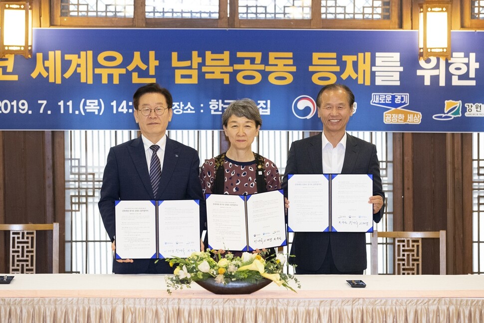
Various groups are working to transform the DMZ into a site of peace and reconciliation. For example, there is the agreement reached this past July by the provinces of Gyeonggi and Gangwon and the CHA to work with North Korea to submit a joint bid for the DMZ to be registered as a UNESCO World Heritage site.
“This past June, the inter-Korean summit in Panmunjom reconfirmed that the DMZ is a place of peace and coexistence. This is the perfect opportunity to support an inter-Korean joint bid [for the DMZ’s registration],” said Lee Jae-myung, governor of Gyeonggi Province.
During a speech at the UN General Assembly last month, South Korean Moon Jae-in also proposed that South and North Korea work together toward that end.
By Park Kyung-man, North Gyeonggi correspondent
Please direct comments or questions to [english@hani.co.kr]

Editorial・opinion
![[Column] Season 2 of special prosecutor probe may be coming to Korea soon](https://flexible.img.hani.co.kr/flexible/normal/500/300/imgdb/original/2024/0426/3317141030699447.jpg "[Column] Season 2 of special prosecutor probe may be coming to Korea soon") [Column] Season 2 of special prosecutor probe may be coming to Korea soon
[Column] Season 2 of special prosecutor probe may be coming to Korea soon![[Column] Park Geun-hye déjà vu in Yoon Suk-yeol](https://flexible.img.hani.co.kr/flexible/normal/500/300/imgdb/original/2024/0424/651713945113788.jpg "[Column] Park Geun-hye déjà vu in Yoon Suk-yeol") [Column] Park Geun-hye déjà vu in Yoon Suk-yeol
[Column] Park Geun-hye déjà vu in Yoon Suk-yeol- [Editorial] New weight of N. Korea’s nuclear threats makes dialogue all the more urgent
- [Guest essay] The real reason Korea’s new right wants to dub Rhee a founding father
- [Column] ‘Choson’: Is it time we start referring to N. Korea in its own terms?
- [Editorial] Japan’s rewriting of history with Korea has gone too far
- [Column] The president’s questionable capacity for dialogue
- [Column] Are chaebol firms just pizza pies for families to divvy up as they please?
- [Column] Has Korea, too, crossed the Rubicon on China?
- [Correspondent’s column] In Japan’s alliance with US, echoes of its past alliances with UK
Most viewed articles
- 1After election rout, Yoon’s left with 3 choices for dealing with the opposition
- 2Two factors that’ll decide if Korea’s economy keeps on its upward trend
- 3Noting shared ‘values,’ Korea hints at passport-free travel with Japan
- 4AI is catching up with humans at a ‘shocking’ rate
- 5Why Kim Jong-un is scrapping the term ‘Day of the Sun’ and toning down fanfare for predecessors
- 6South Korea officially an aged society just 17 years after becoming aging society
- 7Korea’s 1.3% growth in Q1 signals ‘textbook’ return to growth, says government
- 8Value of Korean won down 7.3% in 2024, a steeper plunge than during 2008 crisis
- 9‘We must say no’: Seoul defense chief on Korean, USFK involvement in hypothetical Taiwan crisis
- 10Is Japan about to snatch control of Line messenger from Korea’s Naver?