hankyoreh
Links to other country sites 다른 나라 사이트 링크
[Reportage] The DMZ that’s not on land
Korea’s demilitarized zone (DMZ) doesn’t only exist on land.
The DMZ runs for 248km across the Korean Peninsula from Goseong County, Gangwon Province, in the east to Paju, Gyeonggi Province, in the west, and then continues into the Yellow Sea as a “maritime DMZ.” This area constitutes the estuary of the Han River, running for 67km from the mouth of the Imjin River (at Manu Village, Tanhyeon Township, Paju) to Mal Island, next to Boreum Island, Gangwha County. But unlike the overland DMZ, there’s no military demarcation line (MDL) here.
In the 1953 Korean Armistice Agreement, the two sides agreed to declare the Han River estuary to be neutral waters and open it up to civilian traffic. But during the 66 years since then, South Korea’s Ministry of National Defense and the United Nations Command (UNC) haven’t allowed ships to take advantage of that neutrality. Instead, South and North Korea have built military bases in the ports that once served ships and lined the river banks with heavy weaponry, just as they did on the overland DMZ. Once-prosperous ports withered away, and surrounding villages were roped into the Civilian Control Zone (CCZ).
In a military agreement reached on Sept. 19, 2018, South and North Korea defined the Han River estuary as “waters for joint use” and even performed a joint waterway survey and drafted charts of the area. But the discussion was suspended after North Korea-US talks ran aground.
Along the 67km-long Han River estuary, which extends from the mouth of the Imjin River in Paju past the Jo River in Gimpo and to the open sea by Boreum Island in Gangwha County, three observatories have been built that offer a glimpse of towns across the river and the lives of the North Koreans living there.
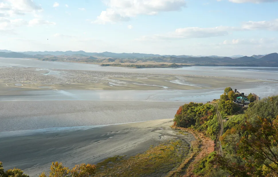
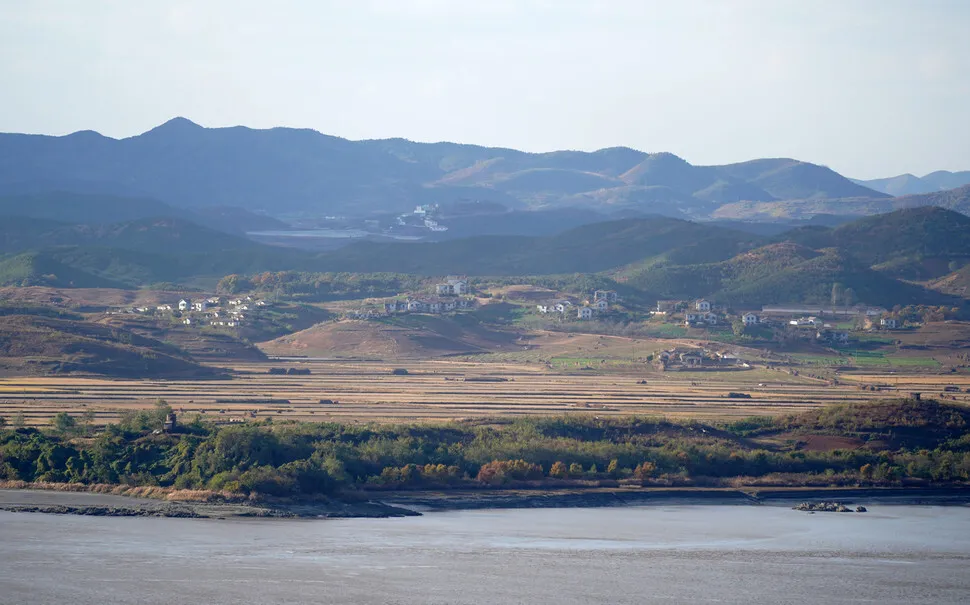
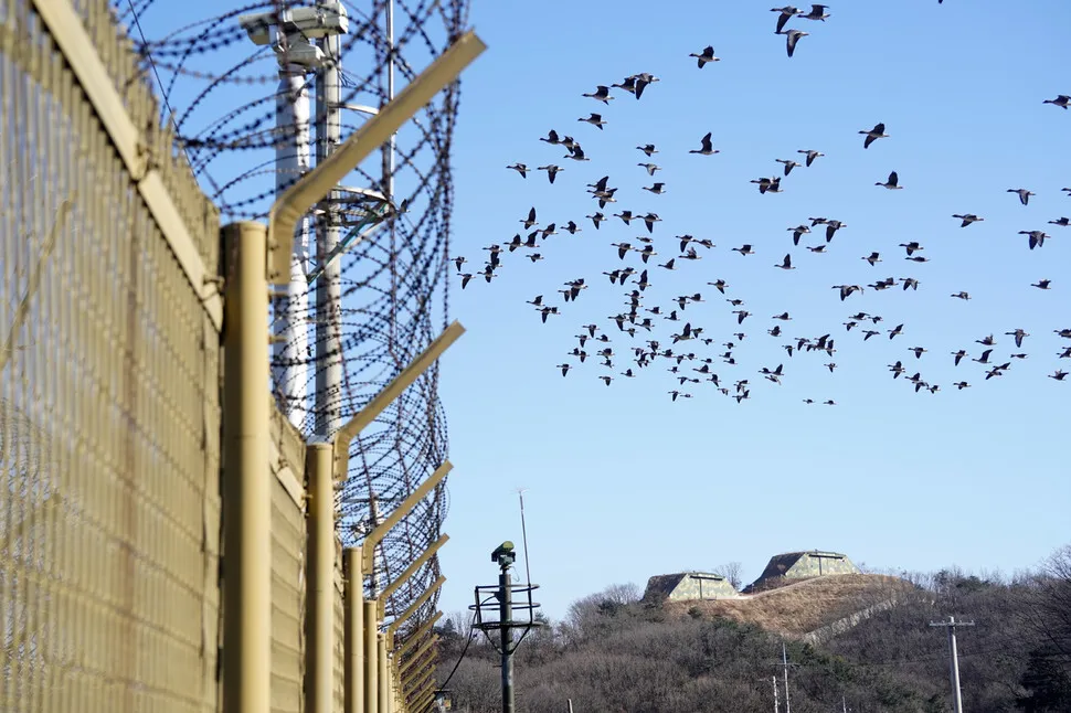
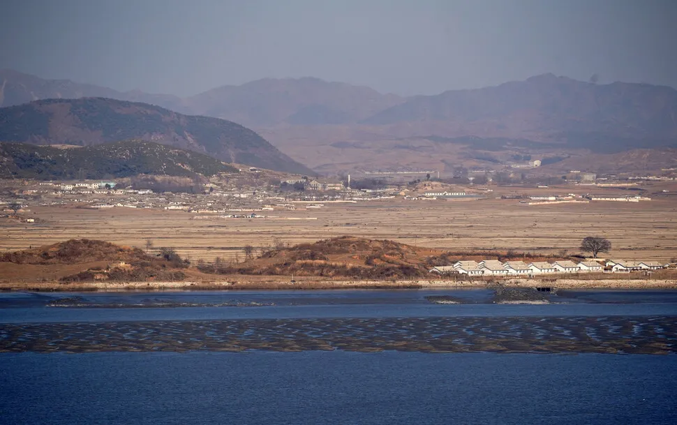
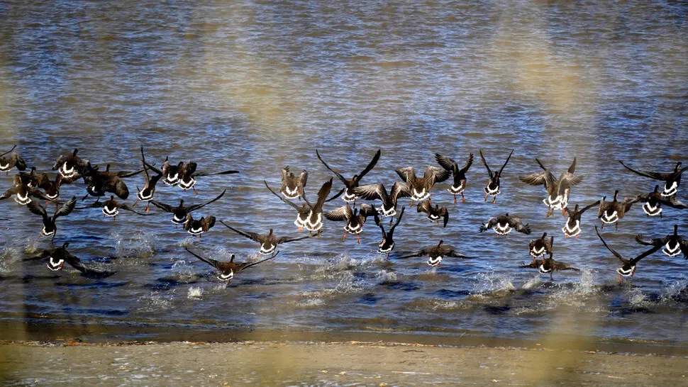
On Oct. 16, the autumnal landscape on both sides of the river as viewed from Odusan (Mt. Odu) Unification Tower, in Seongdong Village, Tanhyeon Township, Paju, looked peaceful and relaxing. Flocks of geese were flying above the barbed-wire fence, a common sight at this stopover point for migratory birds. About 2km to the north in the fields of Imhan Village, Gaepung County, North Hwanghae Province, the locals were busy bringing in the fall harvest. Farmers transporting goods in A-frame carriers, cows munching on the crass, and people on bicycles made for a bucolic sight. The fine weather offered a clear view of buildings in the village, including a museum to Kim Il-sung, a threshing floor, and an elementary school.
At the juncture of the Imjin and Han rivers, Mt. Odu (118m) was a strategic stronghold even during the Three Kingdoms Period, a place where Goguryeo and Baekje fought for hegemony over the Han River basin.
The section of the river that flows west from the observatory at Mt. Odu is sometimes called the Jo River, “jo” meaning “grandfather.” That’s what people in Gimpo used to call the Han River estuary, the name suggesting that the Han River ages over the course of its 400km journey, from fresh water to the sea. An alternative meaning is that the river is as relaxed as an old man.
Past the barbed-wire fence along Siam Village, Haseong Township, Gimpo, a village on the Jo River that’s inside the Civilian Control Line (CCL), is Aegi Peak, with an elevation of 155m. Along with the observatory at the top, Aegi Peak has been a site of serious friction with North Korea: it’s the place where a religious group annoyed the North Korean government by hanging Christmas lights on a tower and where conservative groups launched balloons filled with anti-North propaganda leaflets into the North. The tower was dismantled in 2014, and currently the “eco peace park” is being built there. Across from Aegi Peak is Amsil Village in Gaepung County, North Korea.
Continuing on from Aegi Peak toward Gangwha Island, there are a series of small towns along the river: Jogang Village, Yonggang Village, and Bogugot Village. Jogang Port was a distribution point for goods bound for Seoul from the three southern provinces of Chungcheong, Jeolla, and Gyeongsang, as well as a center for trade with the western coast. On the other side of the river, in North Korea’s Gaepung County, is a village of the same name; between them is a small island known as Yu Isle, where a North Korean cow that was swept down the Imjin River in 1996 briefly took refuge. Gimpo is currently working on a plan to set up a “unification economic zone” at the two Jogang villages and to purchase Yu Isle and turn it into an “island of peace.”
Jogang Port isn’t the only old port on the Jo River that’s awaiting restoration: there are also Mageun Port and Gangryeong Port, which once served as the gate to Gaeseong. “Restoring the old ports and repairing the port towns is a project that we can keep working on regardless of fluctuations in inter-Korean relations,” said Kim Dong-seong, with the Gyeonggi Research Institute.
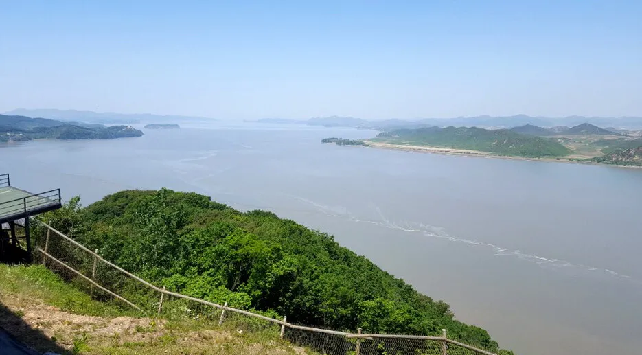
Cheolsan Village, on the northern tip of Gangwha Island, is the site of the Gangwha Peace Observatory, built atop Jejeok Peak, which means “suppressing the Communist Party.” From this observatory, 1.8km away from North Korea, you don’t have to look through the binoculars to see the Yeonbaek Plains and 20 villages, including Dangdupo, Yuldong, Tandong, and Yujeongdong.
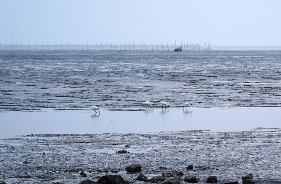
After meeting the Yeseong River at the northern coast of Gangwha Island, the Han River flows west past Gyodong Island, Boreum Island (habitat of the black-faced spoonbill), and tiny Mal Island into the Yellow Sea.
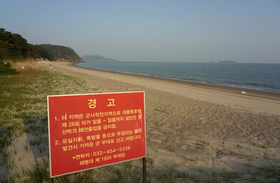
While the armistice agreement (clause 5 of article 1) grants South and North Korean civilians freedom of navigation in the Han River estuary, continuing military clashes in this neutral area impelled the two militaries to bring the banks of the river under their direct control and to restrict civilian navigation.
Navigation has only been permitted on an extremely limited basis in the neutral waters of the Han River estuary. It wasn’t until 1990 that a South Korean vessel passed through, a dredging vessel that was repairing dikes along the Han River that had been wiped out in a flood. Another ship was dispatched to rescue the cow on Yu Isle in 1997, a “turtle ship” sailed from Seoul to Tongyeong in 2005. South and North Korea initiated a discussion about setting up a “special zone for peace and cooperation in the West Sea” and utilizing the Han River estuary during the inter-Korean summit in October 2007, but such efforts were halted when inter-Korean relations entered a chill during the Lee Myung-bak administration.
Hopes of utilizing the Han River estuary were rekindled when South and North Korea agreed to develop military measures to guarantee the shared use of the area during their summit in Pyongyang in Sept. 2018. The two sides immediately set up a joint team that surveyed 70km of the estuary, an area of 280 square kilometers, from Manu Village in Paju to Mal Island in Gangwha County, from Nov. 5 to Dec. 9. The team also produced maritime charts that show the depth of the waters, the shoreline, and the location of reefs. According to the original plan, the area was supposed to be opened to civilian ships on a probationary basis this April, but those efforts stalled after the breakdown of talks during the North Korea-US summit in Hanoi.
This past April, the city of Gimpo and NGOs that advocate opening up the Han River estuary to shipping held a protest aimed at the South and North Korean governments in which 10 ships set out from Jeollyu Village, crossed the fishing boundary, and made their way to the edge of the neutral waters. In July 2018, NGO members made a 35km voyage from Yeouido in Seoul past Haengju Ferry Landing in Goyang, Singoksujung Weir, and Jeollyu Village all the way to the fishery’s boundary.
Experts think that navigation on the Han River estuary could help orchestrate change in inter-Korean relations despite the current dispute over North Korea’s nuclear program and UN sanctions. “Since the armistice agreement declares the Han River estuary to be neutral waters and guarantees free navigation there, the estuary could gain international recognition as a waterway shared by the two Koreas without getting wrapped up in unnecessary political debate like the NLL [Northern Limit Line] in the West Sea. Opening up the Han River estuary would be the first step toward realizing new development not only in Gimpo, but also in Paju and Goyang, which are all trapped on the Han River,” said Kang Tae-ho, former director of the Hankyoreh Peace Institute, during the DMZ Forum, hosted by Gyeonggi Province on Sept. 19.
Given its historical status as a center of fishing, shipping, and transportation, the Han River estuary is regarded as an ideal place for inter-Korean exchange and cooperation projects. And since last year’s inter-Korean summit, civilian navigation is only one of a range of development projects that are being considered or implemented under the name of inter-Korean cooperation projects: a peace zone on the Jangdan Peninsula and Gyodong Island, a special economic zone at the Jo River in Gimpo, an expressway connecting Munsan and Dorasan, and the DMZ peace trail.
However, there’s also a considerable need for preservation at the Han River estuary. As the only untouched brackish water zone on the Korean Peninsula, the estuary boasts rich biological diversity and maintains ecologically outstanding wetlands and fine natural scenery. The Ministry of Environment took the step of designating 60.7 square kilometers of wetland around the Han River estuary as protected wetlands in 2006.
“A large number of rare plants and animals are known to be living around the Han River estuary, including hawks, white-tailed eagles, golden eagles, white-naped cranes, swan geese, bean geese, Seoul frogs, leopard cats, and water crowfoot — as well as the black-faced spoonbill, a globally endangered species. Since a detailed survey of the aquatic ecosystem has never been carried out, there are presumably unrecorded species, too,” said Kim Jin-han, a researcher at the National Institute of Biological Resources.
Environmental groups in cities around the Han River estuary, including Incheon, Paju, and Goyang, agree on the need for carrying out ecological resource surveys and earmarking more wetlands for aquatic conservation at the estuary.
“The biggest problem with the discussion about the waters of the Han River estuary is that everyone is talking about development. Humans haven’t been allowed to set foot in the neutral waters there for 70 years, and the government needs to take preemptive steps, such as putting more wetlands under protection, for the conservation of those waters,” said Roh Hyeon-gi, co-president of the Paju Coalition for the Environmental Movement.
By Park Kyung-man, North Gyeonggi Correspondent
Please direct comments or questions to [english@hani.co.kr]

Editorial・opinion
![[Editorial] Inquiry must clarify if gov’t pressure led to unfair Westinghouse settlement](https://flexible.img.hani.co.kr/flexible/normal/500/300/imgdb/original/2025/0820/5317556787190915.jpg "[Editorial] Inquiry must clarify if gov’t pressure led to unfair Westinghouse settlement") [Editorial] Inquiry must clarify if gov’t pressure led to unfair Westinghouse settlement
[Editorial] Inquiry must clarify if gov’t pressure led to unfair Westinghouse settlement![[Column] Does ‘KPop Demon Hunters’ count as Korean? Does it matter?](https://flexible.img.hani.co.kr/flexible/normal/500/300/imgdb/original/2025/0820/2117556793887318.jpg "[Column] Does ‘KPop Demon Hunters’ count as Korean? Does it matter?") [Column] Does ‘KPop Demon Hunters’ count as Korean? Does it matter?
[Column] Does ‘KPop Demon Hunters’ count as Korean? Does it matter?- [Editorial] Trump and Putin’s Ukraine deal is a warning to countries like Korea
- [Editorial] ‘Two-track’ approach with Japan does not mean disregarding past
- [Editorial] Lee’s gestures toward North Korea, Japan are a welcome step
- [Editorial] Korea-Japan summit must acknowledge past while looking to future
- [Column] Abandon all hope, you who enter radical politics
- [Column] Can Korea say ‘no’ to the US?
- [Column] Why Yoon is cosplaying as a prisoner of conscience
- [Editorial] Cho Kuk’s pardon must serve as impetus for prosecution reform
Most viewed articles
- 1Presidential office orders probe into KHNP’s 50-year ‘slave contract’ with Westinghouse
- 2[Column] Does ‘KPop Demon Hunters’ count as Korean? Does it matter?
- 3Korea mulls how to respond if US demands ‘strategic flexibility’ of USFK at summit
- 4Now in their 90s, unconverted long-term prisoners ask to be sent to North Korea
- 5Ex-interior minister charged with ordering blackout on media outlets during martial law
- 6Former bodyguard’s dark tale of marriage to Samsung royalty
- 7[Editorial] Inquiry must clarify if gov’t pressure led to unfair Westinghouse settlement
- 8USFK sprayed defoliant from 1955 to 1995, new testimony suggests
- 9[Column] Abandon all hope, you who enter radical politics
- 10[Editorial] Trump and Putin’s Ukraine deal is a warning to countries like Korea