hankyoreh
Links to other country sites 다른 나라 사이트 링크
[Korea travels] Secluded Ulleung Island make for perfect getaway retreat
Slosh. Churn. Splash.
The boat rocked every time a wave hit. The collective battle against seasickness had begun. Passengers asked the crew on board for motion sickness bags.
Those who couldn't control their nausea rested on the floor. The waves of the East Sea were rough. The only thing we could see from the windows was the open sea. When would we finally arrive at the island?
It took three hours after embarking on the boat for the island to become visible. I had arrived in Ulleung County, North Gyeongsang Province, located at the end of the East Sea.
Ever since the outbreak of the COVID-19 pandemic, Ulleung Island has been gaining popularity as a safe and “uncontaminated” travel destination.
While the island was mainly visited by tourists in their 50s and 60s traveling in groups in the past, nowadays it has become a hot place for young travelers including newlyweds, campers and solo backpackers.
This is because the island boasts clean air and beautiful scenery while at the same time maintaining a special quality since it’s not a place that can be visited so easily or at any time.
According to a survey conducted by Ulleung County, the number of tourists who visited Ulleung Island from January to October this year stood at 430,423 (as of Oct. 31), the highest number recorded. This figure has already surpassed the previous record of 415,180 visitors recorded back in 2013.
A walking path to enjoy unexplored coastal areas
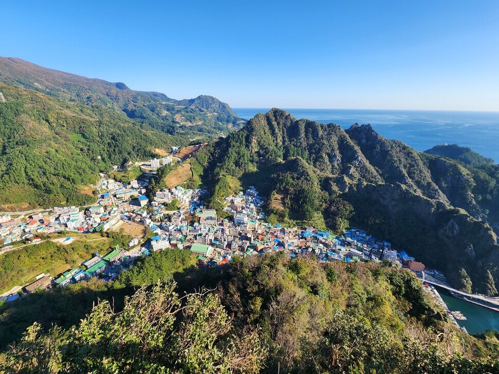
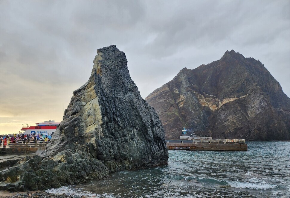
On Oct. 18, I arrived at Dodong Port, the gateway to Ulleung Island. The port is located in Dodong, which is also where you can find the Ulleung County Office, other government offices, lodgings, and restaurants. This neighborhood serves as the administrative, economic, and transportation center of Ulleung Island.
The name Dodong originated from “Dobangcheong," a self-governing branch office established there when residents first came to the island after orders were given to develop the island back in 1882 during the 19th year of King Gojong's reign.
“Dobangcheong” means a place where many people live and the “Do” was later taken to make the new name, Dodong.
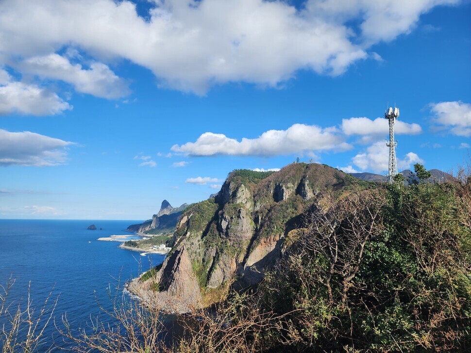
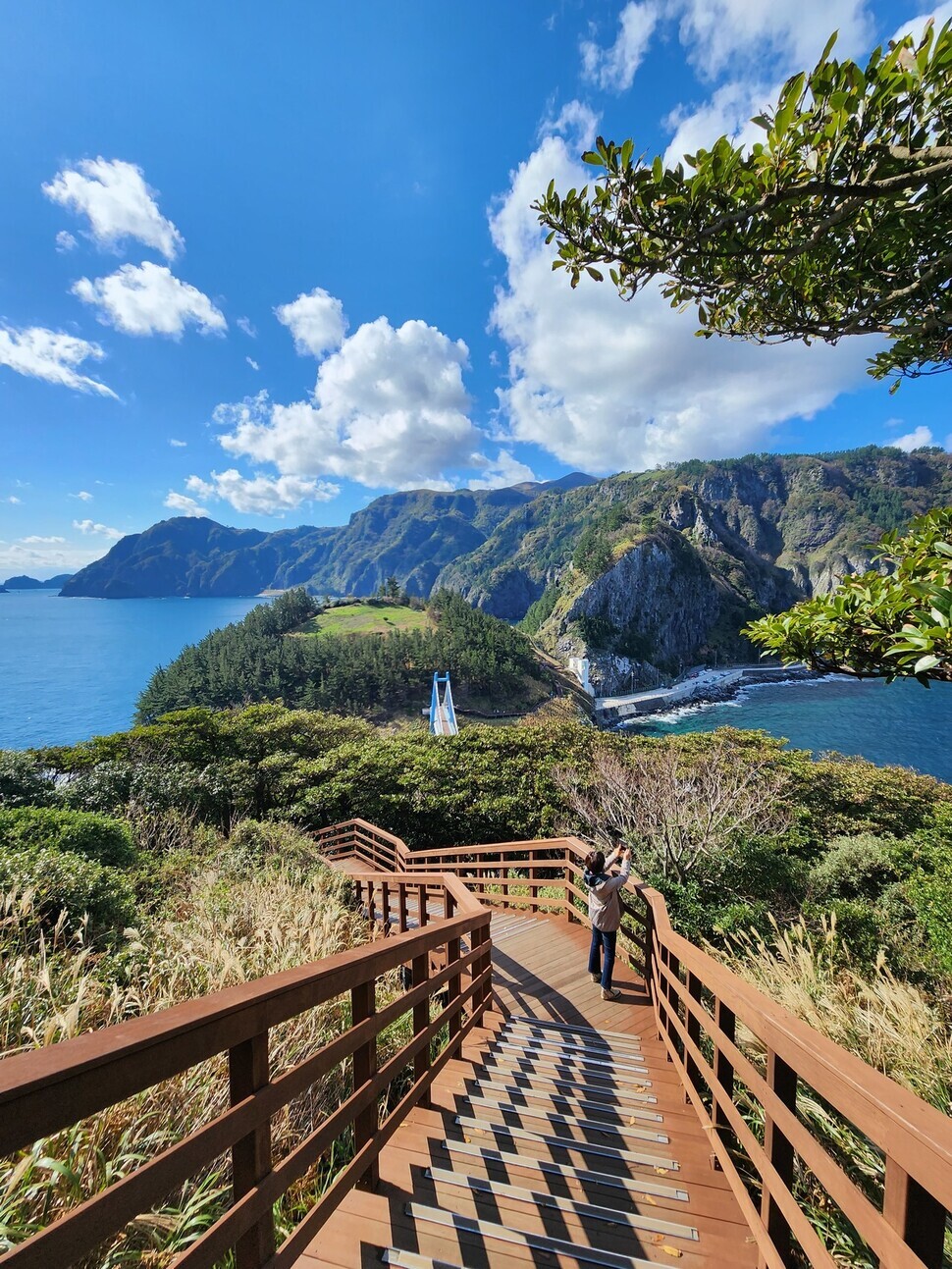
As soon as you arrive in Dodong, you come across a nice, out-stretched walking route called the Haengnam Coastal Walking Path. The trail is 2.8 km long and runs from Dodong Village to Jeodong Village and takes 1 hour and 30 minutes to complete. It’s a great option to do either on the day you arrive in Dodong port or just before you hop back on the boat for departure.
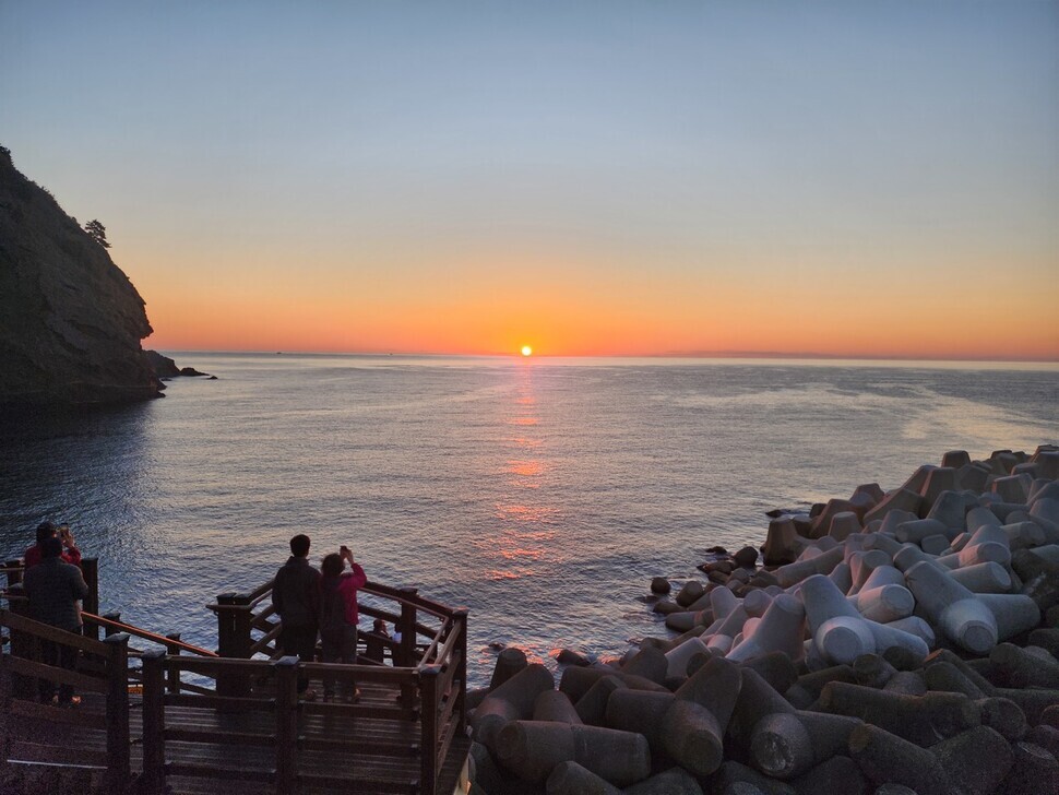
To go down this trail, I made my way to the rooftop on the fourth floor of the Dodong Port passenger terminal and took the path from there. This is also known as a great place to watch the sunrise.
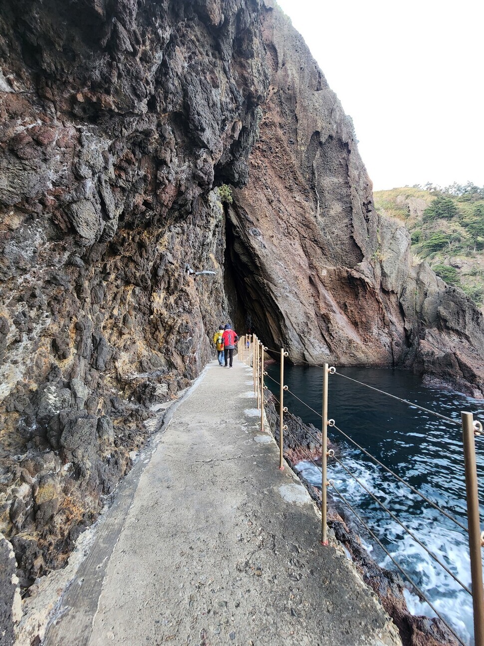
When you’re looking at the deep blue ocean and the scenery, then the narrow path along the coastline won’t ever get boring.
Listening to the sounds of the waves along the path, I passed a cave between some rock formations and crossed a bridge overlooking the sea. The color of the sea stops you right in your tracks.
I could see the emerald sea between the sea caves dug into the coastal cliffs. As I turned my eyes to the rugged cliffs, I could see yellow leopard plants (Farfugium japonicum) and purple hydrangea, which bloom in the autumn.
As a volcanic island, this unique past of Ulleung can be seen along the Haengnam Coastal Walking Path through geological structures that retain the characteristics of early volcanic activity.
Basaltic lava flows, clastic sedimentary rocks formed when pieces of rock are moved by landslides, ignimbrite formed when volcanic ash is piled up in a hot state, and trachyte, a type of extrusive rock, are dispersed throughout the path.
Gwaneum Island, an island within an island
After walking along the Haengnam Coastal Walking Path, I took a bus (No. 1, 2, or 22) from Dodong Port and headed to Gwaneum Island.
The uninhabited island is located in the rural village of Cheonbu on the northern side of Ulleung County. With an area measuring 71,405 square meters, a circumference of 800 meters, and a height of 106 meters, it is the third largest among the islands attached to Ulleung Island.
According to the book “Collection of Origins of Korean Place Names: Gyeongsang Edition”, Gwaneum Island was originally called “Kaksae” Island because there were so many streaked shearwater birds there. Nowadays, these birds have disappeared and instead the area has become the habitat of groups of black-tailed seagulls.
It’s easy to get to Gwaneum Island by foot since it’s connected by a bridge to Ulleung Island. There’s an entrance fee of 4,000 won for adults.
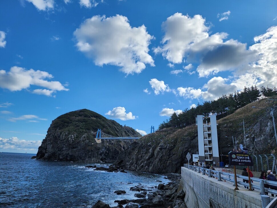
The bridge, which is 140 meters long and 3 meters wide, boasts a beautiful view of the ocean on both sides. The color of the ocean water seen from the bridge is a beautiful, clear jade tone. It thus comes as no surprise that the area around Gwaneum Island is famous for snorkeling.
Ranked among Ulleung Island’s top three scenic views, Gwaneum Island includes two walking trails — “Course A” (350m) and “Course B” (500m) — and three observation platforms. The trails take roughly an hour to complete.
Course A allows visitors to see Juk Island, Naesujeon Beach, and radiating columnar joints — fan-shaped cracks that arise as lava rapidly cools. Course B offers views of the Samseon Rocks and Juk Island. It also has the Gwaneum Caves, two sea caves measuring around 14 meters high, although they are located down below, where visitors have to take a boat to see them.
A walk along Gwaneum Island is like strolling through a green garden on the sea. It is rich with a variety of plant life, including camellia trees, silver grass, wallflowers, and mugwort.
Restoration areas can also be found for the preservation of Veronica nakaiana and Bupleurum latissimum Nakai, both plants that only grow on Ulleung Island. With the island forest on one side and the sea on the other, everywhere you look gives a refreshing feeling.
The following day, I took the old Hyanmok trail to get to the Hyangmok observation deck in Taeha, a village on Ulleung Island’s west side. A roughly 4-kilometer path that goes from Taeha to the village of Hyeonpo, the Hyangmok trail takes around two hours to walk. Ulleung Island has nine paths like this one, where old trails have been redesigned as walking courses.
Taeha was the old capital of the state of Usan, and it was where the settlers of Ulleung Island first set foot. Juniper populations here have been stunted by the rough winds, and the landscape is quite rugged. The Hyangmok mountain trail leading up from Taeha is flanked by camellia trees and other plant life.
As you head toward the summit along this trail, you can see the white structure of the Taeha Lighthouse (Ulleung Island Sea Route Signal Management Office). First lit in 1958, this lighthouse serves as a protector of vessels sailing the waters around the island.
Right behind the lighthouse is the Hyangmok observatory. The name “Hyangmok” comes from the fact that at the time of the island’s settlement, there was little scrub in the vicinity of this observatory site; instead, it was filled with beautiful juniper trees (“hyangnamu” in Korean).
From the Hyangmok observation deck, you can view the exquisite scenic view of Ulleung Island’s northern coast. It offers a magnificent scene of a sheer cliff face with rugged rocks standing over the sea. The superb landscape of dense trees befits the name “Ulleung,” which means “verdant hills.”
Also visible from the Hyangmok observatory is Daepunggam, a rocky mountain at the island’s northwestern tip. The name “Daepunggam” comes from this being the place where the old residents would wait for high winds (“daepung” in Korean) heading toward the mainland after they finished building their boats. The site includes a natural juniper habitat that has been designated as a Natural Monument.
Those wanting to take a stroll along a path through lush Ulleung Island’s virgin forest should head for Nari Basin on the island’s north side. A crater basin formed by the collapse of a crater to the north of Seongin Peak, Nari Busan is the only flatland on Ulleung Island, surrounded by Seongin Peak, Mount Mireuk, Mount Cheondu, and Nari Ridge.
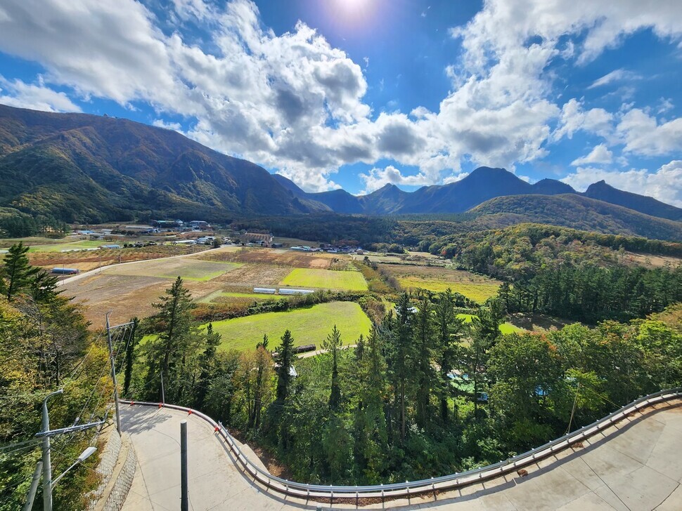
The name “Nari” — referring to a kind of lily — is said to have come from the history of Ulleung Island’s settlers, who had no staple crop when they first arrived in this village. Instead, they are said to have survived by eating the roots of Hanson’s lily, a species that is native to sites all around the village.
In Nari Basin, you can see populations of Ulleung chrysanthemums (designated as Natural Monument No. 52) and island thyme, along with the springs of Yongchulso and Sillyeongsu. Visitors can experience all the beauty of nature on the Nari Basin forest route and a virgin forest course.
“Ulleung Island has also been called ‘Lock-and-Key Island,’ a name that means ‘you can only come and go here as nature allows,’” explained Park Sun-deok, a culture and tourism guide with the Ulleung County Office.
“It isn’t an easy place to visit, but once you come here, you’re enchanted by its beauty. The air is clear, and there are many works of art shaped by nature through its sea, mountains, and basins,” Park added.
Dokdo is an unmissable visit for anyone traveling to Ulleung Island — but going there is said to be even more challenging than a journey overseas.
With the constantly changing weather and tall waves, there are quite a few days when boats don’t travel there at all. Some even jokingly suggest that you “need to have practiced good deeds for three generations” to reach it. In a given year, it’s possible to land on the islets on about 200 of the days.
I boarded a boat for Dokdo from Ulleung Island’s Jeodong Port. The trip there took around an hour and 40 minutes.
Dokdo consists of an east and west islet and 89 rocks and reefs. The total area is 187,554 square meters. It was formed 4.6 million years ago by a volcanic eruption — making it two million years older than Ulleung Island, which emerged 2.5 million years ago. In 1982, it was designated as National Monument No. 336.
Visitors are allotted 30 minutes to view the island. The area accessible to tourists is located around the east islet’s dock.
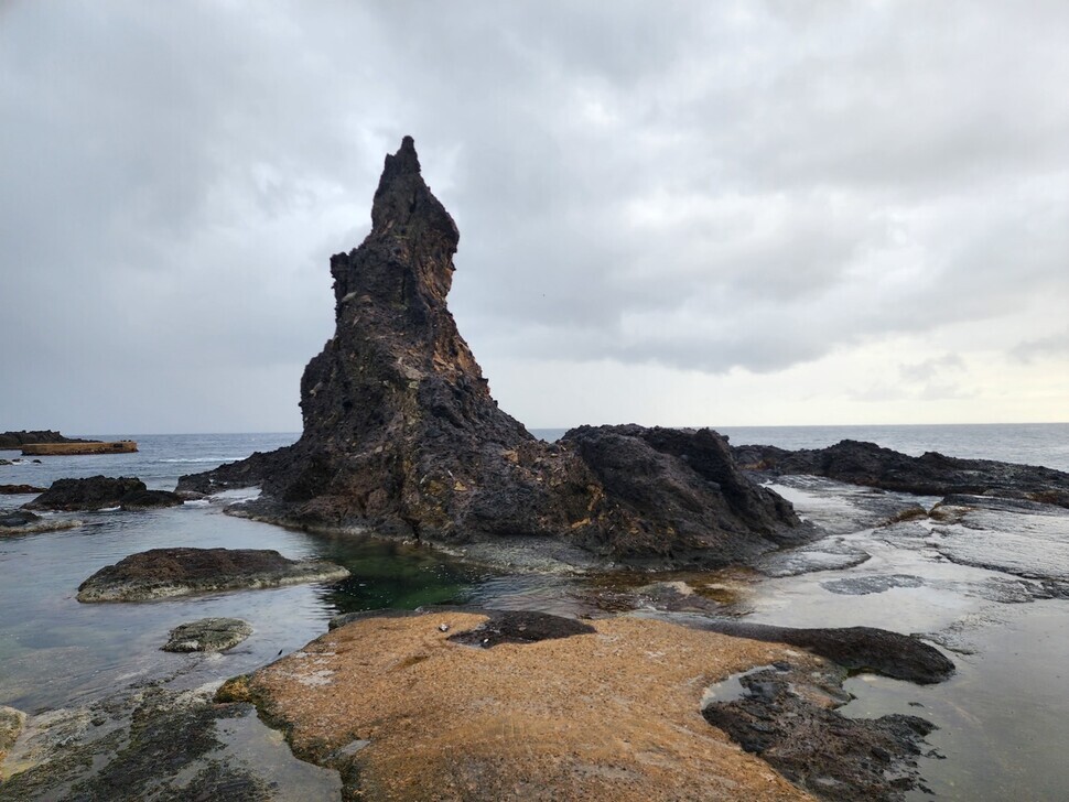
Sutdol Rock, which is located to the dock’s right, takes its name from the Korean word for “whetstone,” which it resembles. This is where members of the Dokdo volunteer forces are said to have honed their knives while staying here in the period after the Korean War.
To the left is Buchae (Fan) Rock, with its rugged surface shaped by the pounding of wind and waves. Visitors are not allowed to go up to Dokdo’s highest point of Usan Peak (98.6), but the site houses the Dokdo security forces, a lighthouse and a heliport.
Also near the east islet’s dock is a picture-taking area for visitors. Travelers stand in line with South Korean flags to capture images of themselves standing next to the “Dokdo Isabu Road” sign and a monument for the dock’s construction, which bears the words “Eastern End of South Korea.”
Looking across the way, visitors can see the west islet separated from the east one by a shallow waterway measuring 151m across. At the west islet’s center is Daehan Peak, which reaches 168.5m in height; underneath it, the terrain slopes off sharply.
Next to the west island are Tanggeon Peak, Chotdae (Candlestick) Rock, and Samhyeongje (Three Brothers) Cavern Rock. These rocks show nature in its most pristine form.
Those who visit Dokdo can apply for an “honorary resident” certificate. These certificates are given to both Korean and overseas visitors who have stepped on the islets or circled them by boat at least once. To have one issued, send in an application at the Dokdo Management Office website (intodokdo.go.kr).
“You felt pretty queasy coming to Ulleung Island, right? That’s why it’s called Ulleung Island, because the waves churn so much [‘ulleong’ in Korean] that they give you seasickness. But we’ve ironed out the waves today so you can have a peaceful journey back. It’s not ‘Churning Island’ anymore — it’s ‘Calm Island.’”
One of the crew members was joking with passengers as I boarded the ferry back to the mainland after my three-day journey. All of us laughed heartily — we were in the same boat, so to speak.
In contrast with the day of my arrival on Ulleung Island, the waters were now peaceful. None of the passengers struggled with seasickness.
The journey back from Ulleung Island takes three hours by sea. This is another part of the trip: for now, the island can only be reached by boat, although flights are expected to become available in 2026.
An Ulleung Airport is currently being built to receive small aircraft in the village of Sadong. Once it’s open, travelers from Seoul will be able to reach the island in roughly an hour by plane. Like Jeju Island, Ulleung Island will be a place you can visit as a same-day travel destination.
Today’s Ulleung Island — a “lock-and-key island” that is not easily visited, that you can only travel to as nature permits — is now three years away from being opened up.
Transportation: Travelers can take boats to Ulleung Island from the four ports of Gangneung, Mukho, Hupo (Uljin), and Pohang. In the winter months from December to February, only cruise ships travel from Hupo and Pohang.
In Hupo Port’s case, Ulleung Sunflower Cruise trips depart once a day at 8:30 am. A one-way journey takes four-and-a-half hours and costs 70,000 won (for a third class seat). Tickets can be reserved at the Ulleung Sunflower Cruise website (jhferry.com).
Ulleung cruises also depart from Pohang once a day at 11:50 pm. The trip takes six-and-a-half hours one way and costs 66,500 won (for a shared cabin). Tickets can be reserved at the UL Cruise website (ulcruise.co.kr). Make sure to have identification on you when you board.
The Ulleung County ferry information site (ferry.ulleung.go.kr) includes information about passenger service to and from the island. Visitors can find out about the passenger terminals, boarding, departure schedules, and the current status of ships traveling to and from Ulleung Island.
Photos and article by Her Yun-hee, staff reporter
Please direct questions or comments to [english@hani.co.kr]

Editorial・opinion
![[Column] When ‘fairness’ means hate and violence](https://flexible.img.hani.co.kr/flexible/normal/500/300/imgdb/original/2024/0516/7417158465908824.jpg "[Column] When ‘fairness’ means hate and violence") [Column] When ‘fairness’ means hate and violence
[Column] When ‘fairness’ means hate and violence![[Editorial] Yoon must stop abusing authority to shield himself from investigation](https://flexible.img.hani.co.kr/flexible/normal/500/300/imgdb/original/2024/0516/4417158464854198.jpg "[Editorial] Yoon must stop abusing authority to shield himself from investigation") [Editorial] Yoon must stop abusing authority to shield himself from investigation
[Editorial] Yoon must stop abusing authority to shield himself from investigation- [Column] US troop withdrawal from Korea could be the Acheson Line all over
- [Column] How to win back readers who’ve turned to YouTube for news
- [Column] Welcome to the president’s pity party
- [Editorial] Korea must respond firmly to Japan’s attempt to usurp Line
- [Editorial] Transfers of prosecutors investigating Korea’s first lady send chilling message
- [Column] Will Seoul’s ties with Moscow really recover on their own?
- [Column] Samsung’s ‘lost decade’ and Lee Jae-yong’s mismatched chopsticks
- [Correspondent’s column] The real reason the US is worried about Chinese ‘overcapacity’
Most viewed articles
- 1China calls US tariffs ‘madness,’ warns of full-on trade conflict
- 2[Column] US troop withdrawal from Korea could be the Acheson Line all over
- 3[Editorial] Yoon must stop abusing authority to shield himself from investigation
- 4[Column] When ‘fairness’ means hate and violence
- 5[Column] How to win back readers who’ve turned to YouTube for news
- 6US has always pulled troops from Korea unilaterally — is Yoon prepared for it to happen again?
- 7[Book review] Who said Asians can’t make some good trouble?
- 8Naver’s union calls for action from government over possible Japanese buyout of Line
- 9Could Korea’s Naver lose control of Line to Japan?
- 10[Editorial] Korea must respond firmly to Japan’s attempt to usurp Line