hankyoreh
Links to other country sites 다른 나라 사이트 링크
[Reportage] Exploring the DMZ

Cutting across the midsection of the Korean Peninsula, the Demilitarized Zone (DMZ) has ironically been the world’s most heavily militarized zone for the past 70 years. With more landmines buried than can even be determined, it is a “national border,” but one that no person can cross.
Now a new wind is blowing into this space of total separation. With their military agreement on Sept. 19 of last year, South and North Korea agreed to develop measures to prohibit all military training in the DMZ region and turn it into a zone of peace. In that instant, the DMZ was reborn as a land of hope, ushering in a new future for the peninsula. Called the “secret forest,” the DMZ has woods, valleys, streams, and wetlands existing in excellent preservation, forming a paradise for wild flora and fauna where threatened species like the red-crowned crane, Asian black bear, Siberian musk deer, and long-tailed goral exist peacefully alongside some 40% of the peninsula’s animal species. The natural environment shows the possibilities of a shift from security tourism to ecotourism and peace tourism. Over the past year, implementation of the military agreement has been weakening – but the dream of turning this symbol of division into a space of peace continues to grow.
From Seoul, the DMZ at Paju, Gyeonggi Province, is just around 50km away. But covering that distance requires crossing countless borders and barriers. The northern communities of the Greater Seoul Area – including Goyang, Gimpo, Paju, and Yeoncheon in Gyeonggi Province – present various “Cold War landscapes” due to the military units and facilities that have existed to protect Seoul for the past 70 years.
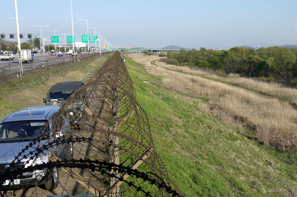
As you travel along the Jayu-ro Motorway, a road that runs from Seoul to the border between Goyang and Paju along the lower course of the Han River, the view of the Han River estuary is blocked by the impenetrable ceasefire line. Ahead, enormous concrete masses stand watch over major corners. These are antitank barricades. On the Han and other waterways like Gongneung and Munsan Streams, military protection structures called “dragons’ teeth” cut across like monsters. These fortifications were introduced in large numbers along streams on the border in the 1970s to prevent the advance of enemy tanks.
The first gateway from Goyang and Paju into the northern part of the Civilian Control Zone (CCZ) is Unification Bridge, where the zone checkpoint is set up. As you cross through the heavy barricade at the bridge’s entrance, the CCZ appears. Past the Civilian Control Line awaits the sturdy general outpost (GOP) barbed-wire fence at the Southern Limit Line, marking the entrance to the DMZ. On the other side of the forbidding GOP fence’s gate, the DMZ begins – Korean land, but a place where everything is governed and controlled by the UN Command. The view inside the DMZ shows the cold GOP fence, guard posts like impregnable fortresses, and roads used by soldiers. Within this space, over 10,000 young South and North Koreans once hung grenades from their chests and pointed their gun barrels at one another in battle.
Over 10,000 S. and N. Korean soldiers battle in future DMZ
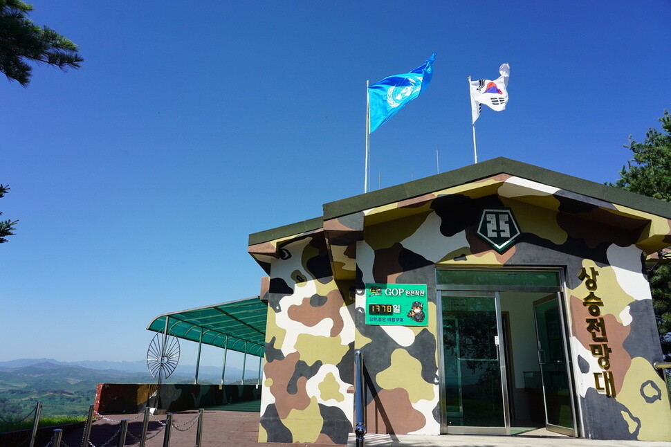
Seen from the observation post (OP) of the Army’s 25th Infantry Division in Yeoncheon’s Baekhak Township on Sept. 18, the DMZ felt close enough that the eye could make out “Tunnel No. 1” – discovered in 1971 – and the North Korean People’s Army guard posts and Northern Limit Line.
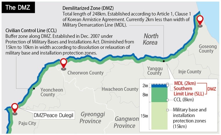
The DMZ is a military buffer zone built in accordance with the armistice agreement in July 1953, stretching for 2km on either side along the Military Demarcation Line (MDL, also known as the Armistice Line) for 248km (155 miles) from the Imjin River estuary to the East Sea coast at Goseong in Gangwon Province. Due to the forward deployment of the armistice line by both South and North, the width has been narrowed to 1.5km.
The reason for this narrowing was the decision by both sides since the 1960s to move their fences closer to the MDL to gain vantage points for observing the other side’s activities within the DMZ. A South Korean military official explained, “The North was first to move its fences toward the Armistice Line, setting up an encampment-type OP on high ground within the DMZ. In response, our forces obtained permission from the UN Command to move our fences inward and set up an OP on high ground inside the DMZ.” The forward deployment of South and North Korean fences reduced the area of the DMZ by around 43% from 992 square kilometers at the time of the armistice to 570 square kilometers today.
Before the war, the area where Sami Stream runs through the DMZ was the Yeoncheon Plain, a region of high-quality rice production. Today, it has become a wetland.
Following their military agreement on Sept. 19, 2018, South and North Korea each removed a guard post around the Sami Stream.
The presence of heavy weaponry in the DMZ is a violation of the armistice agreement, which states that the DMZ may only be entered for the purpose of civil administration and for recovery projects, with no more than a thousand people entering from either side. The agreement also restricted the armament of civil police to semi-automatic firearms, to block the use of machine guns and prevent large-scale military clashes.
But in the late 1950s, North Korea brought Soviet-manufactured AK automatic weapons into the DMZ; by the end of the 1960s, South Korean troops were fielding M16 automatic weapons there. From the 1970s until the 1990s, both the South and North Korean militaries massively increased their military presence in the DMZ, rushing to build guard posts and install powerful weapons, including heavy machine guns.
While the area around the truce line had relaxed somewhat after the armistice agreement, that all changed during the Cold War buildup in the mid-1960s. An increasing number of skirmishes there prompted the South Korean military to replace a wooden palisade built along the Southern Limit Line (SLL) with barbed wire fencing, a project that began in 1967. Between 1965 and 1969, there were a total of 415 firefights along the DMZ, in which hundreds of people were killed. The Nixon Doctrine in 1969 led to a considerable decrease in military clashes around the armistice line, and hardly any clashes have occurred since the 1990s.
The military agreement reached by South and North Korea on Sept. 19, 2018, led to the probationary closure of 20 guard posts along the DMZ, heralding a time of transition for a site of military confrontation between the two sides.
Cheorwon County damaged by irresponsible removal from the Civilian Control LineReferences to the DMZ often include a section technically outside of the DMZ but inside the Civilian Control Line (CCL), which was demarcated the year after the armistice was signed, in 1954. The CCL, which includes the area 10km from the MDL, was jointly drawn by the commander of USFK and by South Korea’s Minister of National Defense for the purpose of setting a boundary on the DMZ. While this border isn’t signposted, military outposts and checkpoints were set up on roads in the area, with soldiers blocking civilian passage.
Each year, some 6 million tourists visit tourist sites along the DMZ, including 14 observatories and Imjingak Park.
Jangdan Peninsula in Paju offers access to arable land that is frequented by farmers living elsewhere. But even though this land is privately owned, access is strictly regulated, with farmers required to enter after sunrise and to leave before sunset, leading to frequent altercations with soldiers manning the checkpoints. There have also been many casualties in areas around the CCL that are dotted with mines that no one is willing to acknowledge laying.
Between 1968 and 1973, the administration of Park Chung-hee set up 113 “strategic villages” inside the CCL both to beef up defense at the front as a psychological warfare initiative. For various reasons — including controversy over the violation of property rights (most of these villages occupied private land), pressure to develop the areas in question, and transportation difficulties — the number of villages has gradually decreased, leaving just eight today. Four are in Gyeonggi Province (Daeseong-dong Village, in Paju; Unification Village, also in Paju; Haemaru Village; and Hoengsan Village, in Yeoncheon County), and four are in Gangwon Province (Igil Village, Jeongyeon Village, Yugok Village, and Mahyeon Village, all in Cheorwon County).
Along with building the Peace Trails along stretches of the DMZ in Goseong, Cheorwon, and Paju, the South Korean government is reportedly considering the options of building roads to link South and North Korea and completely opening up the CCL restricted area. Some locals and environmental groups argue for maintaining the CCL out of fears about unchecked development along the DMZ.
“Our priority is an agreement with North Korea about the principle of ecological, historical, and cultural conservation in and around the DMZ. We need to stop ecologically destructive development around the CCL and near the DMZ, such as the highway between Munsan and Dorasan,” the Korea Federation of Environmental Movements (KFEM) said in a press conference in front of the Blue House on Sept. 19.
“The natural environment of Cheorwon has been greatly damaged by shrinking the CCL without taking any precautions. Conservation of the CCL is necessary for conservation of the DMZ,” said Choi Jong-su, a resident of Cheorwon County.
After Yangji Village (located in Dongsong Township, Cheorwon County) was placed outside the CCL boundaries in 2012, huge solar installations and factory farms were set up there by outsiders through dubious means, which reportedly caused serious damage to the environment.
In 1971, the Park Chung-hee government established a green belt, or an area of restricted development, in the outskirts of Seoul. In addition to suppressing urban growth, the green belt designation was aimed at protecting and concealing various military installations that had been set up around Seoul for capital defense following an unsuccessful raid on the Blue House by North Korean commandos on Jan. 21, 1968. This green belt tied up 1,166 square kilometers of land in Gyeonggi Province, and one corps, four divisions, subordinate units, and various military facilities took up residence in the administrative limits of Goyang, the largest city in the northern half of the province. South Korea’s Ministry of Land, Infrastructure, and Transport is currently pushing to dissolve the green belt around Seoul and to build three new cities in the capital region, including one at Changreung in Goyang.
In December 1972, the Park Chung-hee administration enacted the Military Facility Protection Act, which designated a huge area, covering 27km from the MDL, as a “military facility protection zone.” This designation placed major restrictions on the development of the region, the lifestyle of locals, and the exercise of property rights by preventing the construction of new buildings and requiring deliberation with the military before new developments could go ahead. Seventy-five percent of the area of Gyeonggi Province’s seven northern cities and counties fell into the military facility protection zone, including 94% of Yeoncheon County, 91% of Paju, 76% of Gimpo, 53% of Yangju, and 43% of Goyang. It was not until the end of last year that the Ministry of National Defense agreed to remove 337 square kilometers of land from the military facility protection zone, which covers 8.8% of South Korean territory. Lee Jae-myung, governor of Gyeonggi Province, said that since “northern Gyeonggi Province has made a special sacrifice for security, it ought to receive special compensation.”
By Park Kyung-man, North Gyeonggi correspondent
Please direct comments or questions to [english@hani.co.kr]

Editorial・opinion
![[Column] Season 2 of special prosecutor probe may be coming to Korea soon](https://flexible.img.hani.co.kr/flexible/normal/500/300/imgdb/original/2024/0426/3317141030699447.jpg "[Column] Season 2 of special prosecutor probe may be coming to Korea soon") [Column] Season 2 of special prosecutor probe may be coming to Korea soon
[Column] Season 2 of special prosecutor probe may be coming to Korea soon![[Column] Park Geun-hye déjà vu in Yoon Suk-yeol](https://flexible.img.hani.co.kr/flexible/normal/500/300/imgdb/original/2024/0424/651713945113788.jpg "[Column] Park Geun-hye déjà vu in Yoon Suk-yeol") [Column] Park Geun-hye déjà vu in Yoon Suk-yeol
[Column] Park Geun-hye déjà vu in Yoon Suk-yeol- [Editorial] New weight of N. Korea’s nuclear threats makes dialogue all the more urgent
- [Guest essay] The real reason Korea’s new right wants to dub Rhee a founding father
- [Column] ‘Choson’: Is it time we start referring to N. Korea in its own terms?
- [Editorial] Japan’s rewriting of history with Korea has gone too far
- [Column] The president’s questionable capacity for dialogue
- [Column] Are chaebol firms just pizza pies for families to divvy up as they please?
- [Column] Has Korea, too, crossed the Rubicon on China?
- [Correspondent’s column] In Japan’s alliance with US, echoes of its past alliances with UK
Most viewed articles
- 1[Column] Season 2 of special prosecutor probe may be coming to Korea soon
- 2‘We must say no’: Seoul defense chief on Korean, USFK involvement in hypothetical Taiwan crisis
- 3Division commander ordered troops to enter raging flood waters before Marine died, survivor says
- 4Is N. Korea threatening to test nukes in response to possible new US-led sanctions body?
- 5Is Japan about to snatch control of Line messenger from Korea’s Naver?
- 6No good, very bad game for Korea puts it out of Olympics for first time since 1988
- 7[Editorial] Korea’s surprise Q1 growth requires objective assessment, not blind fanfare
- 8Korea’s 1.3% growth in Q1 signals ‘textbook’ return to growth, says government
- 9N. Korean delegation’s trip to Iran shows how Pyongyang is leveraging ties with Moscow
- 10Amnesty notes ‘erosion’ of freedom of expression in Korea in annual human rights report