hankyoreh
Links to other country sites 다른 나라 사이트 링크
Khanun expected to pummel Korea with heavy rainfall, powerful gales starting Wednesday
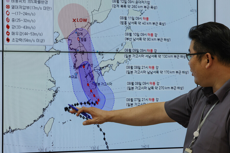
Typhoon Khanun is projected to sweep across the entirety of the Korean Peninsula in nearly full force after making landfall on the country’s southeastern coast on Thursday morning.
In a briefing on Monday morning, the Korea Meteorological Administration (KMA) stated that Khanun, which has strong winds reaching speeds of 35 meters per second (68 knots), was expected to turn northwest Monday evening, then continue northward on the western side of Kagoshima, Japan. The administration projected the storm will reach waters 90 kilometers southwest of Busan at 9 am on Thursday.
The service stated that this will put the entire country in the direct path of the typhoon’s reach from Wednesday through Friday.
The KMA said that the storm is expected to fall in the category of “strong typhoon” when it makes landfall in South Korea. A strong typhoon has a maximum sustained wind speed of more than 33 m/s and less than 44 m/s (64-85 knots) — forceful enough to derail a train.
The storm is expected to bring with it very strong winds that could make it difficult for people to walk and intense precipitation, especially in the eastern part of the country.
Maximum sustained wind speeds on the country’s southeastern coast are expected to reach around 40 m/s between Wednesday and Friday. At this speed of wind, vehicles will struggle to travel at normal speeds and people will not be able to stand outside without anchoring themselves.
Parts of the northeastern coast in Gangwon Province are expected to receive more than 500 millimeters, or upwards of 19 inches, of rain between Wednesday and Friday, while the country’s southeastern regions are expected to be hit with more than 300 millimeters.
However, it is still difficult to predict whether the typhoon will maintain its momentum while moving across the Korean Peninsula.
“The typhoon is expected to weaken, as it will be blocked by high terrain in Japan’s Kyushu region, but with water temperatures on the southern coast nearing 29 degrees Celsius, one to two degrees above normal, it may be able to gain strength again due to warmer sea surface temperatures,” explained Park Jeong-min, a KMA weather analyst, at the briefing.
Predictions show the western coast to be no better off.
“Localized gusts of wind and heavy rain clouds may form due to atmospheric instability in the west where warm, dry air descending from the northwest of the peninsula will meet the moist, warm air driven by the typhoon,” the weather agency explained in the briefing.
As a result, 50 to 100 millimeters of rain is expected to fall between Wednesday and Friday in Buan, North Jeolla Province, where the 2023 World Scout Jamboree was taking place, and strong winds of 15 to 25 m/s are expected.
By Shin So-yoon, staff reporter
Please direct questions or comments to [english@hani.co.kr]

Editorial・opinion
![[Editorial] Exploiting foreign domestic workers won’t solve Korea’s birth rate problem](https://flexible.img.hani.co.kr/flexible/normal/500/300/imgdb/original/2024/0626/5517193887628759.jpg "[Editorial] Exploiting foreign domestic workers won’t solve Korea’s birth rate problem") [Editorial] Exploiting foreign domestic workers won’t solve Korea’s birth rate problem
[Editorial] Exploiting foreign domestic workers won’t solve Korea’s birth rate problem![[Column] Kim and Putin’s new world order](https://flexible.img.hani.co.kr/flexible/normal/500/300/imgdb/original/2024/0625/9617193034806503.jpg "[Column] Kim and Putin’s new world order") [Column] Kim and Putin’s new world order
[Column] Kim and Putin’s new world order- [Editorial] Workplace hazards can be prevented — why weren’t they this time?
- [Editorial] Seoul failed to use diplomacy with Moscow — now it’s resorting to threats
- [Column] Balloons, drones, wiretapping… Yongsan’s got it all!
- [Editorial] It’s time for us all to rethink our approach to North Korea
- [Column] Why empty gestures matter more than ever
- [Editorial] Seoul’s part in N. Korea, Russia upgrading ties to a ‘strategic partnership’
- [Column] The tragedy of Korea’s perpetually self-sabotaging diplomacy with Japan
- [Column] Moon Jae-in’s defense doublethink
Most viewed articles
- 1After 7 years, South Korea resumes live-fire drills on islands a stone’s throw from North
- 2Nuclear South Korea back up for debate as North cozies up to Russia
- 3CIA record confirms US ‘completely destroyed’ Seoul’s Haebangchon in 1950 bombardment
- 4‘Disposable’: How illegal temp work practices push migrants in Korea into risky jobs
- 5Dispatched into unknown danger, foreign day laborers were defenseless against blaze
- 6How 17 km of river could be a fertile bed for NK-China-Russia cooperation
- 7[Reportage] On Yeonpyeong Island, residents fear military drills will snowball into war
- 8Sex trade in Southeast Asia sees increase of Korean males
- 9[Editorial] Exploiting foreign domestic workers won’t solve Korea’s birth rate problem
- 10[Seoul travels] Mullae: a place to get lost and perhaps rediscover yourself